
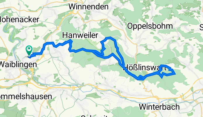
Im Sämann 104, Waiblingen nach Im Sämann 105, Waiblingen
A cycling route starting in Waiblingen, Baden-Württemberg, Germany.
Overview
About this route
- 1 h 22 min
- Duration
- 36.1 km
- Distance
- 512 m
- Ascent
- 553 m
- Descent
- 26.3 km/h
- Avg. speed
- 524 m
- Avg. speed
Route quality
Waytypes & surfaces along the route
Waytypes
Track
28.6 km
(79 %)
Quiet road
4 km
(11 %)
Surfaces
Paved
22.2 km
(62 %)
Unpaved
13.9 km
(38 %)
Asphalt
21 km
(58 %)
Gravel
13.3 km
(37 %)
Continue with Bikemap
Use, edit, or download this cycling route
You would like to ride Im Sämann 104, Waiblingen nach Im Sämann 105, Waiblingen or customize it for your own trip? Here is what you can do with this Bikemap route:
Free features
- Save this route as favorite or in collections
- Copy & plan your own version of this route
- Sync your route with Garmin or Wahoo
Premium features
Free trial for 3 days, or one-time payment. More about Bikemap Premium.
- Navigate this route on iOS & Android
- Export a GPX / KML file of this route
- Create your custom printout (try it for free)
- Download this route for offline navigation
Discover more Premium features.
Get Bikemap PremiumFrom our community
Other popular routes starting in Waiblingen
 Tour de Schnait
- Distance
- 36.3 km
- Ascent
- 379 m
- Descent
- 378 m
- Location
- Waiblingen, Baden-Württemberg, Germany
 Rems und Neckar
- Distance
- 52.1 km
- Ascent
- 181 m
- Descent
- 196 m
- Location
- Waiblingen, Baden-Württemberg, Germany
 Runde um den Schurwald
- Distance
- 41.4 km
- Ascent
- 489 m
- Descent
- 534 m
- Location
- Waiblingen, Baden-Württemberg, Germany
 Ameisenbühl 1, Waiblingen nach Ameisenbühl 8, Waiblingen
- Distance
- 19 km
- Ascent
- 7 m
- Descent
- 16 m
- Location
- Waiblingen, Baden-Württemberg, Germany
 Neckar / Rems Tour
- Distance
- 41.6 km
- Ascent
- 242 m
- Descent
- 242 m
- Location
- Waiblingen, Baden-Württemberg, Germany
 Abendrunde
- Distance
- 29.6 km
- Ascent
- 412 m
- Descent
- 415 m
- Location
- Waiblingen, Baden-Württemberg, Germany
 Waiblingen über Schmiden am Besinnungsweg entlang bis zum Mount Oeffingen und zum Max-Eyth -See
- Distance
- 21.6 km
- Ascent
- 72 m
- Descent
- 185 m
- Location
- Waiblingen, Baden-Württemberg, Germany
 WN: Langer Kurs über Bittenfeld - Winnenden - Bouch
- Distance
- 43.2 km
- Ascent
- 479 m
- Descent
- 479 m
- Location
- Waiblingen, Baden-Württemberg, Germany
Open it in the app