
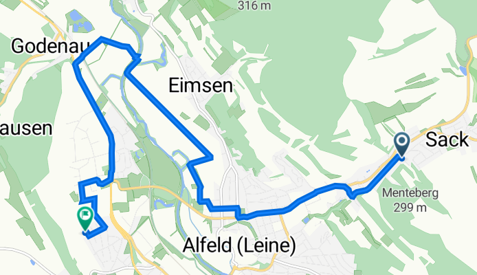
Immental 6, Alfeld (Leine) nach Nelly-Sachs-Weg 5, Alfeld (Leine)
A cycling route starting in Alfeld, Lower Saxony, Germany.
Overview
About this route
- 30 min
- Duration
- 10.3 km
- Distance
- 49 m
- Ascent
- 74 m
- Descent
- 21 km/h
- Avg. speed
- 137 m
- Avg. speed
Route quality
Waytypes & surfaces along the route
Waytypes
Quiet road
3.5 km
(34 %)
Track
2.4 km
(23 %)
Surfaces
Paved
6.8 km
(66 %)
Unpaved
0.2 km
(2 %)
Asphalt
6.1 km
(59 %)
Paving stones
0.4 km
(4 %)
Continue with Bikemap
Use, edit, or download this cycling route
You would like to ride Immental 6, Alfeld (Leine) nach Nelly-Sachs-Weg 5, Alfeld (Leine) or customize it for your own trip? Here is what you can do with this Bikemap route:
Free features
- Save this route as favorite or in collections
- Copy & plan your own version of this route
- Sync your route with Garmin or Wahoo
Premium features
Free trial for 3 days, or one-time payment. More about Bikemap Premium.
- Navigate this route on iOS & Android
- Export a GPX / KML file of this route
- Create your custom printout (try it for free)
- Download this route for offline navigation
Discover more Premium features.
Get Bikemap PremiumFrom our community
Other popular routes starting in Alfeld
 Fahrrad Tour von Alfeld nach Winzenburg
- Distance
- 12.2 km
- Ascent
- 146 m
- Descent
- 131 m
- Location
- Alfeld, Lower Saxony, Germany
 Vergleich der Strecken Alfeld - Buchholz in der Nordheide
- Distance
- 374.1 km
- Ascent
- 280 m
- Descent
- 304 m
- Location
- Alfeld, Lower Saxony, Germany
 Alfeld-Bodenburg-Gandersheim-Freden
- Distance
- 86.1 km
- Ascent
- 612 m
- Descent
- 612 m
- Location
- Alfeld, Lower Saxony, Germany
 Alfelder_Berge_Hohe_Tafel
- Distance
- 12.2 km
- Ascent
- 418 m
- Descent
- 415 m
- Location
- Alfeld, Lower Saxony, Germany
 Absolutes Flachland
- Distance
- 56.3 km
- Ascent
- 138 m
- Descent
- 169 m
- Location
- Alfeld, Lower Saxony, Germany
 Alfeld Gronau Friedhof
- Distance
- 14.9 km
- Ascent
- 41 m
- Descent
- 49 m
- Location
- Alfeld, Lower Saxony, Germany
 Limmer - Mehle - Salzhemmendorf
- Distance
- 71.3 km
- Ascent
- 373 m
- Descent
- 373 m
- Location
- Alfeld, Lower Saxony, Germany
 Alfeld(Stadtmitte)-Banteln(Bahnhof)
- Distance
- 11.2 km
- Ascent
- 66 m
- Descent
- 73 m
- Location
- Alfeld, Lower Saxony, Germany
Open it in the app