
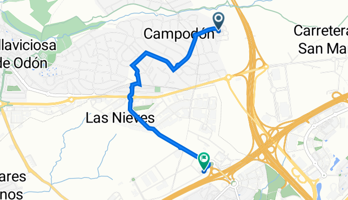
Calle las Liebres, 12, Alcorcón a Calle de Agustín de Betancourt, 53–73, Móstoles
A cycling route starting in Villaviciosa de Odón, Madrid, Spain.
Overview
About this route
- 15 min
- Duration
- 4.1 km
- Distance
- 31 m
- Ascent
- 41 m
- Descent
- 16.3 km/h
- Avg. speed
- 700 m
- Avg. speed

Route quality
Waytypes & surfaces along the route
Waytypes
Quiet road
3.9 km
(97 %)
Busy road
0.1 km
(3 %)
Road
0 km
(<1 %)
Continue with Bikemap
Use, edit, or download this cycling route
You would like to ride Calle las Liebres, 12, Alcorcón a Calle de Agustín de Betancourt, 53–73, Móstoles or customize it for your own trip? Here is what you can do with this Bikemap route:
Free features
- Save this route as favorite or in collections
- Copy & plan your own version of this route
- Sync your route with Garmin or Wahoo
Premium features
Free trial for 3 days, or one-time payment. More about Bikemap Premium.
- Navigate this route on iOS & Android
- Export a GPX / KML file of this route
- Create your custom printout (try it for free)
- Download this route for offline navigation
Discover more Premium features.
Get Bikemap PremiumFrom our community
Other popular routes starting in Villaviciosa de Odón
 El Soto - Pte de Hierro - Fuente de manantiales - Sevilla la Nueva - Cañada real segoviana - Quijorna - Vuelta igual
- Distance
- 64.6 km
- Ascent
- 349 m
- Descent
- 348 m
- Location
- Villaviciosa de Odón, Madrid, Spain
 II Marcha Villaviciosa 2010
- Distance
- 39 km
- Ascent
- 328 m
- Descent
- 323 m
- Location
- Villaviciosa de Odón, Madrid, Spain
 Móstoles-Loranca-Moraleja de Enmedio-Monte Batres-Casarrubios del Monte-El Álamo-Móstoles
- Distance
- 127.9 km
- Ascent
- 556 m
- Descent
- 556 m
- Location
- Villaviciosa de Odón, Madrid, Spain
 Villaviciosa de Odón-Navalcarnero-Villamanta-Sevilla la Nueva
- Distance
- 54.2 km
- Ascent
- 380 m
- Descent
- 382 m
- Location
- Villaviciosa de Odón, Madrid, Spain
 Villaviciosa, desde M501 hasta rotonda (por M506)
- Distance
- 3.9 km
- Ascent
- 81 m
- Descent
- 13 m
- Location
- Villaviciosa de Odón, Madrid, Spain
 desde casa hasta el árbol, atravesando m50 por túnel y hasta casa de campo (colonia de los ángeles)
- Distance
- 28.1 km
- Ascent
- 1,191 m
- Descent
- 1,116 m
- Location
- Villaviciosa de Odón, Madrid, Spain
 enlace golf las lomas ventorro
- Distance
- 44.7 km
- Ascent
- 413 m
- Descent
- 413 m
- Location
- Villaviciosa de Odón, Madrid, Spain
 Ruta 3º ESO
- Distance
- 19.4 km
- Ascent
- 225 m
- Descent
- 225 m
- Location
- Villaviciosa de Odón, Madrid, Spain
Open it in the app