
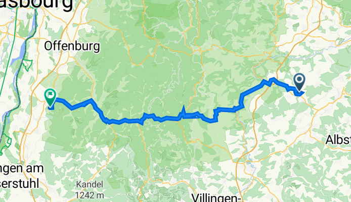
Lerchenstraße 7, Haigerloch nach Mattenweg 78, Lahr/Schwarzwald
A cycling route starting in Haigerloch, Baden-Württemberg, Germany.
Overview
About this route
- 8 h 25 min
- Duration
- 106.7 km
- Distance
- 2,123 m
- Ascent
- 2,446 m
- Descent
- 12.7 km/h
- Avg. speed
- 703 m
- Max. altitude

Route quality
Waytypes & surfaces along the route
Waytypes
Quiet road
38.9 km
(36 %)
Path
21.3 km
(20 %)
Surfaces
Paved
86.6 km
(81 %)
Unpaved
5.3 km
(5 %)
Asphalt
78.1 km
(73 %)
Paved (undefined)
6.3 km
(6 %)
Continue with Bikemap
Use, edit, or download this cycling route
You would like to ride Lerchenstraße 7, Haigerloch nach Mattenweg 78, Lahr/Schwarzwald or customize it for your own trip? Here is what you can do with this Bikemap route:
Free features
- Save this route as favorite or in collections
- Copy & plan your own version of this route
- Split it into stages to create a multi-day tour
- Sync your route with Garmin or Wahoo
Premium features
Free trial for 3 days, or one-time payment. More about Bikemap Premium.
- Navigate this route on iOS & Android
- Export a GPX / KML file of this route
- Create your custom printout (try it for free)
- Download this route for offline navigation
Discover more Premium features.
Get Bikemap PremiumFrom our community
Other popular routes starting in Haigerloch
 Erlaheim1
- Distance
- 20.1 km
- Ascent
- 157 m
- Descent
- 157 m
- Location
- Haigerloch, Baden-Württemberg, Germany
 Kleine Abendrunde Haigerloch
- Distance
- 25.2 km
- Ascent
- 214 m
- Descent
- 226 m
- Location
- Haigerloch, Baden-Württemberg, Germany
 Haigerloch-Eyach-Rottenburg-Weiler-Hirrlingen-Haigerloch
- Distance
- 52.5 km
- Ascent
- 422 m
- Descent
- 418 m
- Location
- Haigerloch, Baden-Württemberg, Germany
 Haigerloch - Horb - Sulz - Haigerloch
- Distance
- 59.5 km
- Ascent
- 401 m
- Descent
- 401 m
- Location
- Haigerloch, Baden-Württemberg, Germany
 Owingen - Zimmern udB
- Distance
- 19.3 km
- Ascent
- 327 m
- Descent
- 225 m
- Location
- Haigerloch, Baden-Württemberg, Germany
 Nette Runde
- Distance
- 22.4 km
- Ascent
- 254 m
- Descent
- 251 m
- Location
- Haigerloch, Baden-Württemberg, Germany
 Haigerloch - Eyach - Unterjesingen
- Distance
- 34.5 km
- Ascent
- 203 m
- Descent
- 288 m
- Location
- Haigerloch, Baden-Württemberg, Germany
 An Eyach und Neckar - Kilometer spulen
- Distance
- 84.3 km
- Ascent
- 574 m
- Descent
- 575 m
- Location
- Haigerloch, Baden-Württemberg, Germany
Open it in the app