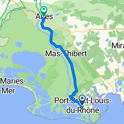
Via Rhona, Port-Saint-Louis-du-Rh么ne 脿 70 Chemin de la Fontaine de Guigue, Fos-sur-Mer
A cycling route starting in Port-Saint-Louis-du-Rh么ne, Provence-Alpes-C么te d'Azur Region, France.
Overview
About this route
- 1 h 36 min
- Duration
- 20.9 km
- Distance
- 48 m
- Ascent
- 47 m
- Descent
- 13.1 km/h
- Avg. speed
- 17 m
- Max. altitude
Route quality
Waytypes & surfaces along the route
Waytypes
Quiet road
11.3 km
(54 %)
Cycleway
4 km
(19 %)
Surfaces
Paved
12.3 km
(59 %)
Unpaved
3.8 km
(18 %)
Asphalt
12.3 km
(59 %)
Gravel
3.8 km
(18 %)
Undefined
4.8 km
(23 %)
Continue with Bikemap
Use, edit, or download this cycling route
You would like to ride Via Rhona, Port-Saint-Louis-du-Rh么ne 脿 70 Chemin de la Fontaine de Guigue, Fos-sur-Mer or customize it for your own trip? Here is what you can do with this Bikemap route:
Free features
- Save this route as favorite or in collections
- Copy & plan your own version of this route
- Sync your route with Garmin or Wahoo
Premium features
Free trial for 3 days, or one-time payment. More about Bikemap Premium.
- Navigate this route on iOS & Android
- Export a GPX / KML file of this route
- Create your custom printout (try it for free)
- Download this route for offline navigation
Discover more Premium features.
Get Bikemap PremiumFrom our community
Other popular routes starting in Port-Saint-Louis-du-Rh么ne
ET4 // Port Saint Louis du Rh么ne - Arles- Distance
- 43.5 km
- Ascent
- 35 m
- Descent
- 18 m
- Location
- Port-Saint-Louis-du-Rh么ne, Provence-Alpes-C么te d'Azur Region, France
Salins de Giraud 脿 la mer- Distance
- 5.9 km
- Ascent
- 0 m
- Descent
- 0 m
- Location
- Port-Saint-Louis-du-Rh么ne, Provence-Alpes-C么te d'Azur Region, France
Zum Phare de Gacholle- Distance
- 23.1 km
- Ascent
- 0 m
- Descent
- 0 m
- Location
- Port-Saint-Louis-du-Rh么ne, Provence-Alpes-C么te d'Azur Region, France
Chemin du Bac de Barcarin Salin, Arles nach Saintes Maries de la Mer- Distance
- 31.5 km
- Ascent
- 0 m
- Descent
- 0 m
- Location
- Port-Saint-Louis-du-Rh么ne, Provence-Alpes-C么te d'Azur Region, France
De Chemin du Fangassier - VC135, Arles 脿 Route du Bac de Barcarin (Embranchement) - RD36c, Arles- Distance
- 6.7 km
- Ascent
- 3 m
- Descent
- 3 m
- Location
- Port-Saint-Louis-du-Rh么ne, Provence-Alpes-C么te d'Azur Region, France
SALIN DE GIRAUD -LES SAINTES MARIES DE LA MER-AIGUES MORTES-ARLES- Distance
- 169.7 km
- Ascent
- 0 m
- Descent
- 0 m
- Location
- Port-Saint-Louis-du-Rh么ne, Provence-Alpes-C么te d'Azur Region, France
Route de Port-Saint-Louis-du-Rh么ne, Port-Saint-Louis-du-Rh么ne 脿 9 Avenue L茅on Gambetta, Saintes-Maries-de-la-Mer- Distance
- 39.6 km
- Ascent
- 5 m
- Descent
- 4 m
- Location
- Port-Saint-Louis-du-Rh么ne, Provence-Alpes-C么te d'Azur Region, France
Via Rhona, Port-Saint-Louis-du-Rh么ne 脿 70 Chemin de la Fontaine de Guigue, Fos-sur-Mer- Distance
- 20.9 km
- Ascent
- 48 m
- Descent
- 47 m
- Location
- Port-Saint-Louis-du-Rh么ne, Provence-Alpes-C么te d'Azur Region, France
Open it in the app


