
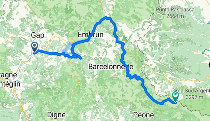
Tallard - Isola 2000
A cycling route starting in Tallard, Provence-Alpes-Côte d'Azur Region, France.
Overview
About this route
A tough route through the Alps with, for example, the short but extremely steep ascent of the Col de Pontis. Additionally, there are two giants with the Col de Vars and the Col de la Bonette. Finally, there is also the final ascent to Isola 2000.
- -:--
- Duration
- 204 km
- Distance
- 4,828 m
- Ascent
- 3,436 m
- Descent
- ---
- Avg. speed
- ---
- Max. altitude
Continue with Bikemap
Use, edit, or download this cycling route
You would like to ride Tallard - Isola 2000 or customize it for your own trip? Here is what you can do with this Bikemap route:
Free features
- Save this route as favorite or in collections
- Copy & plan your own version of this route
- Split it into stages to create a multi-day tour
- Sync your route with Garmin or Wahoo
Premium features
Free trial for 3 days, or one-time payment. More about Bikemap Premium.
- Navigate this route on iOS & Android
- Export a GPX / KML file of this route
- Create your custom printout (try it for free)
- Download this route for offline navigation
Discover more Premium features.
Get Bikemap PremiumFrom our community
Other popular routes starting in Tallard
 Tour de Barcelona dzień 17
- Distance
- 126.1 km
- Ascent
- 367 m
- Descent
- 747 m
- Location
- Tallard, Provence-Alpes-Côte d'Azur Region, France
 2016 Ride Day 72 - Clamensane Circle through Col des Sagnes
- Distance
- 74.4 km
- Ascent
- 963 m
- Descent
- 964 m
- Location
- Tallard, Provence-Alpes-Côte d'Azur Region, France
 étape 4
- Distance
- 42 km
- Ascent
- 778 m
- Descent
- 617 m
- Location
- Tallard, Provence-Alpes-Côte d'Azur Region, France
 Stäfa - Tarifa Stage #7 Monetier Allemont - Avignon
- Distance
- 165.6 km
- Ascent
- 1,872 m
- Descent
- 2,404 m
- Location
- Tallard, Provence-Alpes-Côte d'Azur Region, France
 **07-V. Tallard - Pic de Gleize (170 Km)
- Distance
- 170 km
- Ascent
- 3,974 m
- Descent
- 2,884 m
- Location
- Tallard, Provence-Alpes-Côte d'Azur Region, France
 Tallard (col des guereins)
- Distance
- 36.5 km
- Ascent
- 771 m
- Descent
- 771 m
- Location
- Tallard, Provence-Alpes-Côte d'Azur Region, France
 Tappa 4 FaunTour2k22
- Distance
- 81.8 km
- Ascent
- 561 m
- Descent
- 719 m
- Location
- Tallard, Provence-Alpes-Côte d'Azur Region, France
 2016 Ride Day 73 - Clamensane Circle to Route du Temps
- Distance
- 59.7 km
- Ascent
- 773 m
- Descent
- 774 m
- Location
- Tallard, Provence-Alpes-Côte d'Azur Region, France
Open it in the app