

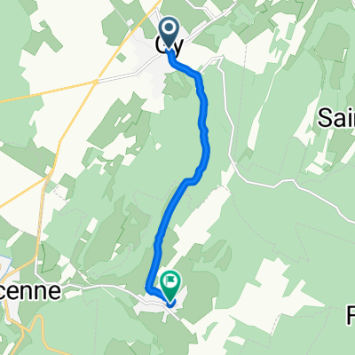
Doubs_Saône_5
A cycling route starting in Gy, Bourgogne-Franche-Comté, France.
Overview
About this route
- -:--
- Duration
- 38.6 km
- Distance
- 703 m
- Ascent
- 706 m
- Descent
- ---
- Avg. speed
- 371 m
- Max. altitude

Route quality
Waytypes & surfaces along the route
Waytypes
Quiet road
16.6 km
(43 %)
Road
15.8 km
(41 %)
Surfaces
Paved
14.3 km
(37 %)
Unpaved
1.9 km
(5 %)
Asphalt
13.5 km
(35 %)
Gravel
1.9 km
(5 %)
Continue with Bikemap
Use, edit, or download this cycling route
You would like to ride Doubs_Saône_5 or customize it for your own trip? Here is what you can do with this Bikemap route:
Free features
- Save this route as favorite or in collections
- Copy & plan your own version of this route
- Sync your route with Garmin or Wahoo
Premium features
Free trial for 3 days, or one-time payment. More about Bikemap Premium.
- Navigate this route on iOS & Android
- Export a GPX / KML file of this route
- Create your custom printout (try it for free)
- Download this route for offline navigation
Discover more Premium features.
Get Bikemap PremiumFrom our community
Other popular routes starting in Gy
 Par les dessus de Mailley
- Distance
- 69.8 km
- Ascent
- 536 m
- Descent
- 537 m
- Location
- Gy, Bourgogne-Franche-Comté, France
 GW-etappe8
- Distance
- 152.8 km
- Ascent
- 964 m
- Descent
- 704 m
- Location
- Gy, Bourgogne-Franche-Comté, France
 011 Gy - Saint Jean de Losne
- Distance
- 85.3 km
- Ascent
- 384 m
- Descent
- 435 m
- Location
- Gy, Bourgogne-Franche-Comté, France
 Autoreille novembre
- Distance
- 5.1 km
- Ascent
- 166 m
- Descent
- 104 m
- Location
- Gy, Bourgogne-Franche-Comté, France
 Gy novembre
- Distance
- 5.1 km
- Ascent
- 109 m
- Descent
- 108 m
- Location
- Gy, Bourgogne-Franche-Comté, France
 tappa9
- Distance
- 105.8 km
- Ascent
- 1,337 m
- Descent
- 746 m
- Location
- Gy, Bourgogne-Franche-Comté, France
 F32 gy to cussey Sur l ognon
- Distance
- 16.2 km
- Ascent
- 311 m
- Descent
- 308 m
- Location
- Gy, Bourgogne-Franche-Comté, France
 Facile à conduire Gy
- Distance
- 10.1 km
- Ascent
- 174 m
- Descent
- 192 m
- Location
- Gy, Bourgogne-Franche-Comté, France
Open it in the app