

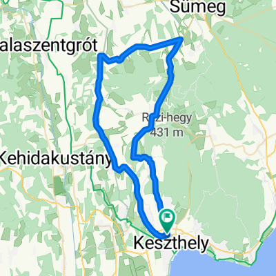
KIS-BALATON kör
A cycling route starting in Keszthely, Zala County, Hungary.
Overview
About this route
- -:--
- Duration
- 77.9 km
- Distance
- 370 m
- Ascent
- 368 m
- Descent
- ---
- Avg. speed
- 211 m
- Max. altitude

Route quality
Waytypes & surfaces along the route
Waytypes
Cycleway
21 km
(27 %)
Quiet road
10.1 km
(13 %)
Surfaces
Paved
54.5 km
(70 %)
Unpaved
4.7 km
(6 %)
Asphalt
54.5 km
(70 %)
Gravel
3.9 km
(5 %)
Route highlights
Points of interest along the route
Point of interest after 6.6 km
Kis-Balaton Látogatóközpont
Point of interest after 28.7 km
Point of interest after 37.6 km
Zalakaros termel-tó és ökopart
Point of interest after 48.8 km
Kilátás a zalaszabari hegyről a Kányavári-szigetre
Point of interest after 49 km
Kilátás
Point of interest after 50.2 km
Continue with Bikemap
Use, edit, or download this cycling route
You would like to ride KIS-BALATON kör or customize it for your own trip? Here is what you can do with this Bikemap route:
Free features
- Save this route as favorite or in collections
- Copy & plan your own version of this route
- Sync your route with Garmin or Wahoo
Premium features
Free trial for 3 days, or one-time payment. More about Bikemap Premium.
- Navigate this route on iOS & Android
- Export a GPX / KML file of this route
- Create your custom printout (try it for free)
- Download this route for offline navigation
Discover more Premium features.
Get Bikemap PremiumFrom our community
Other popular routes starting in Keszthely
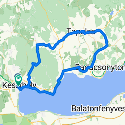 Keszthely-Szigliget-Tapolca-Keszthely
- Distance
- 72.2 km
- Ascent
- 437 m
- Descent
- 443 m
- Location
- Keszthely, Zala County, Hungary
 Balaton Tour A
- Distance
- 34.5 km
- Ascent
- 41 m
- Descent
- 41 m
- Location
- Keszthely, Zala County, Hungary
 KIS-BALATON kör
- Distance
- 77.9 km
- Ascent
- 370 m
- Descent
- 368 m
- Location
- Keszthely, Zala County, Hungary
 KH - Rezi - Sümegprága - Kisgörbö - Karmacs - KH
- Distance
- 54.6 km
- Ascent
- 365 m
- Descent
- 365 m
- Location
- Keszthely, Zala County, Hungary
 KH - Rezi - Óhíd - Zalaszentgrót - Sarmelék - KH
- Distance
- 81.2 km
- Ascent
- 382 m
- Descent
- 385 m
- Location
- Keszthely, Zala County, Hungary
 keszthely
- Distance
- 38.3 km
- Ascent
- 122 m
- Descent
- 134 m
- Location
- Keszthely, Zala County, Hungary
 A piros+ panorámája
- Distance
- 26.9 km
- Ascent
- 385 m
- Descent
- 392 m
- Location
- Keszthely, Zala County, Hungary
 Bakonyerdö túra
- Distance
- 31.1 km
- Ascent
- 292 m
- Descent
- 290 m
- Location
- Keszthely, Zala County, Hungary
Open it in the app