

23GG0520 Cotswolds Gravel X (Final)
A cycling route starting in Luckington, England, United Kingdom.
Overview
About this route
MM Updates 09/05
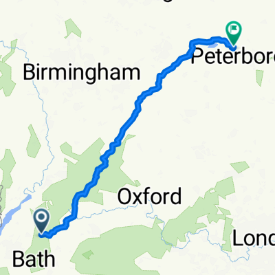
- 12 h 19 min
- Duration
- 91.7 km
- Distance
- 1,012 m
- Ascent
- 1,011 m
- Descent
- 7.4 km/h
- Avg. speed
- 226 m
- Max. altitude

Continue with Bikemap
Use, edit, or download this cycling route
You would like to ride 23GG0520 Cotswolds Gravel X (Final) or customize it for your own trip? Here is what you can do with this Bikemap route:
Free features
- Save this route as favorite or in collections
- Copy & plan your own version of this route
- Split it into stages to create a multi-day tour
- Sync your route with Garmin or Wahoo
Premium features
Free trial for 3 days, or one-time payment. More about Bikemap Premium.
- Navigate this route on iOS & Android
- Export a GPX / KML file of this route
- Create your custom printout (try it for free)
- Download this route for offline navigation
Discover more Premium features.
Get Bikemap PremiumFrom our community
Other popular routes starting in Luckington
 Sherston Hullavington Stanton Grittleton
- Distance
- 34.9 km
- Ascent
- 131 m
- Descent
- 129 m
- Location
- Luckington, England, United Kingdom
 Sherston home
- Distance
- 38.6 km
- Ascent
- 354 m
- Descent
- 440 m
- Location
- Luckington, England, United Kingdom
 Badminton Ride 11.2 Miles
- Distance
- 18.9 km
- Ascent
- 121 m
- Descent
- 122 m
- Location
- Luckington, England, United Kingdom
 Kerry ❤️
- Distance
- 41.3 km
- Ascent
- 180 m
- Descent
- 178 m
- Location
- Luckington, England, United Kingdom
 Cotswolds MTB
- Distance
- 54.3 km
- Ascent
- 758 m
- Descent
- 759 m
- Location
- Luckington, England, United Kingdom
 Sherston to Alderley
- Distance
- 27.5 km
- Ascent
- 262 m
- Descent
- 264 m
- Location
- Luckington, England, United Kingdom
 Badminton
- Distance
- 235.7 km
- Ascent
- 1,784 m
- Descent
- 1,854 m
- Location
- Luckington, England, United Kingdom
 Badminton to Burghley 2020 Route
- Distance
- 235.5 km
- Ascent
- 2,040 m
- Descent
- 2,110 m
- Location
- Luckington, England, United Kingdom
Open it in the app