

Fichtenhäusel Spezial
A cycling route starting in Bärenstein, Saxony, Germany.
Overview
About this route
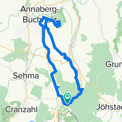
From Fichtenhäusel, the route initially heads to the Czech side via some paved roads up to the 1244 m high Keilberg. Then it returns to the German side, crossing through the forests of the Fichtelberg to the Cranzahl reservoir and finally passing the Bärenstein mountain back to the starting point at Fichtenhäusel.
- -:--
- Duration
- 48.5 km
- Distance
- 1,097 m
- Ascent
- 1,095 m
- Descent
- ---
- Avg. speed
- 1,237 m
- Max. altitude

Route quality
Waytypes & surfaces along the route
Waytypes
Road
19.9 km
(41 %)
Track
17.4 km
(36 %)
Surfaces
Paved
33.9 km
(70 %)
Unpaved
14.1 km
(29 %)
Asphalt
32 km
(66 %)
Ground
4.8 km
(10 %)
Continue with Bikemap
Use, edit, or download this cycling route
You would like to ride Fichtenhäusel Spezial or customize it for your own trip? Here is what you can do with this Bikemap route:
Free features
- Save this route as favorite or in collections
- Copy & plan your own version of this route
- Sync your route with Garmin or Wahoo
Premium features
Free trial for 3 days, or one-time payment. More about Bikemap Premium.
- Navigate this route on iOS & Android
- Export a GPX / KML file of this route
- Create your custom printout (try it for free)
- Download this route for offline navigation
Discover more Premium features.
Get Bikemap PremiumFrom our community
Other popular routes starting in Bärenstein
 Zur kältesten Ort von Deutschland ...
- Distance
- 65.5 km
- Ascent
- 859 m
- Descent
- 877 m
- Location
- Bärenstein, Saxony, Germany
 Annaberg-Buchholz & Pöhlberg
- Distance
- 20.6 km
- Ascent
- 475 m
- Descent
- 476 m
- Location
- Bärenstein, Saxony, Germany
 Fichtenhäusel Spezial
- Distance
- 48.5 km
- Ascent
- 1,097 m
- Descent
- 1,095 m
- Location
- Bärenstein, Saxony, Germany
 Umleitungsempfehlung Fichtelberg-Bärenstein
- Distance
- 2.1 km
- Ascent
- 52 m
- Descent
- 73 m
- Location
- Bärenstein, Saxony, Germany
 Oberwiesenthal & Fichtelberg
- Distance
- 32.5 km
- Ascent
- 596 m
- Descent
- 599 m
- Location
- Bärenstein, Saxony, Germany
 Fichtenhäusel Spezial
- Distance
- 49.1 km
- Ascent
- 1,174 m
- Descent
- 1,172 m
- Location
- Bärenstein, Saxony, Germany
 Rund um den Fichtelberg
- Distance
- 62.1 km
- Ascent
- 916 m
- Descent
- 910 m
- Location
- Bärenstein, Saxony, Germany
 Fichtenhäusel-Zigeunerfelsen - Preßnitztal- Veipert - Fichtenhäusel
- Distance
- 38.5 km
- Ascent
- 787 m
- Descent
- 785 m
- Location
- Bärenstein, Saxony, Germany
Open it in the app