

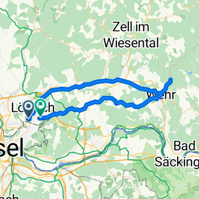
Von Lörrach in den Naturpark Südschwarzwald, Wiese und Vogelpark Steinen
A cycling route starting in Loerrach, Baden-Wurttemberg, Germany.
Overview
About this route
A circular tour from Lörrach into the Southern Black Forest Nature Park, the Wiesental, and the Steinen Bird Park
- 3 h 4 min
- Duration
- 36.2 km
- Distance
- 540 m
- Ascent
- 541 m
- Descent
- 11.8 km/h
- Avg. speed
- 546 m
- Max. altitude
Route quality
Waytypes & surfaces along the route
Waytypes
Track
9.1 km
(25 %)
Quiet road
5.8 km
(16 %)
Surfaces
Paved
23.5 km
(65 %)
Unpaved
8.7 km
(24 %)
Asphalt
21 km
(58 %)
Gravel
8 km
(22 %)
Continue with Bikemap
Use, edit, or download this cycling route
You would like to ride Von Lörrach in den Naturpark Südschwarzwald, Wiese und Vogelpark Steinen or customize it for your own trip? Here is what you can do with this Bikemap route:
Free features
- Save this route as favorite or in collections
- Copy & plan your own version of this route
- Sync your route with Garmin or Wahoo
Premium features
Free trial for 3 days, or one-time payment. More about Bikemap Premium.
- Navigate this route on iOS & Android
- Export a GPX / KML file of this route
- Create your custom printout (try it for free)
- Download this route for offline navigation
Discover more Premium features.
Get Bikemap PremiumFrom our community
Other popular routes starting in Loerrach
 Von Lörrach nach Neuf-Brisach
- Distance
- 63.6 km
- Ascent
- 125 m
- Descent
- 218 m
- Location
- Loerrach, Baden-Wurttemberg, Germany
 Von Lörrach in den Naturpark Südschwarzwald, Wiese und Vogelpark Steinen
- Distance
- 36.2 km
- Ascent
- 540 m
- Descent
- 541 m
- Location
- Loerrach, Baden-Wurttemberg, Germany
 Hohe Mohr
- Distance
- 50.9 km
- Ascent
- 638 m
- Descent
- 638 m
- Location
- Loerrach, Baden-Wurttemberg, Germany
 Lörrach-Kandern-Marzell
- Distance
- 47.1 km
- Ascent
- 890 m
- Descent
- 890 m
- Location
- Loerrach, Baden-Wurttemberg, Germany
 Wiese-Schopfheim-Wehr-Dossenbach-Salzert
- Distance
- 50 km
- Ascent
- 548 m
- Descent
- 469 m
- Location
- Loerrach, Baden-Wurttemberg, Germany
 Dinkelberg - Olsberg Rundfahrt
- Distance
- 46.9 km
- Ascent
- 365 m
- Descent
- 388 m
- Location
- Loerrach, Baden-Wurttemberg, Germany
 Lörrach - St. Chrischona - Lörrach
- Distance
- 33.4 km
- Ascent
- 618 m
- Descent
- 570 m
- Location
- Loerrach, Baden-Wurttemberg, Germany
 Flach wie Holland (den Rhein entlang)
- Distance
- 47.9 km
- Ascent
- 99 m
- Descent
- 98 m
- Location
- Loerrach, Baden-Wurttemberg, Germany
Open it in the app