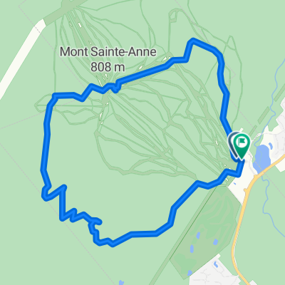
- 11.8 km
- 631 m
- 645 m
- Beaupré, Quebec, Canada
Mont-St-Anne + Petite-Rivière-Saint-François aller-retour
A cycling route starting in Beaupré, Quebec, Canada.
Overview
About this route
Climbs:
-Climb at Saint-Léon of 2.5 km at 4% with a max. of 12% (a little warm-up).
-Climb of Petite-Rivière-Saint-François. Ouff! If you want a climb, you’re going to get one: 1 km at 10%, 2 km at 15% (there is nearly 1 km at 18% in that two km stretch!), 1 km at 8%, then 1 km at 11% for a total of 5 km at 9.5%. For the climb, get ready to suffer and watch out for the steep turns. For the descent, speed and adrenaline are in no short supply. In short, an exhilarating climb!
-Long endless climb from Saint-Cassiens-des-Caps on the 138 (8.4 km at 4.5% and sometimes 9-10%). Even the descent seems long! At the top, we’re still at 740 m altitude.
-A little kicker of 16% near Saint-Féréole.
-...and much more on the 138!
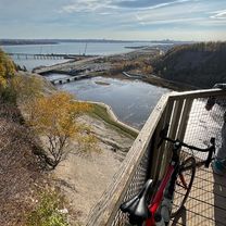
Landscapes:
-Mountains at St-Tites-Des-Caps and Saint Lawrence River at Petite-Rivière-Saint-François.
A man's course!
- -:--
- Duration
- 116.2 km
- Distance
- 1,514 m
- Ascent
- 1,520 m
- Descent
- ---
- Avg. speed
- ---
- Max. altitude
created this 14 years ago
Continue with Bikemap
Use, edit, or download this cycling route
You would like to ride Mont-St-Anne + Petite-Rivière-Saint-François aller-retour or customize it for your own trip? Here is what you can do with this Bikemap route:
Free features
- Save this route as favorite or in collections
- Copy & plan your own version of this route
- Split it into stages to create a multi-day tour
- Sync your route with Garmin or Wahoo
Premium features
Free trial for 3 days, or one-time payment. More about Bikemap Premium.
- Navigate this route on iOS & Android
- Export a GPX / KML file of this route
- Create your custom printout (try it for free)
- Download this route for offline navigation
Discover more Premium features.
Get Bikemap PremiumFrom our community
Other popular routes starting in Beaupré
- libertiste MSA
- Mont-St-Anne + Petite-Rivière-Saint-François aller-retour
- 116.2 km
- 1,514 m
- 1,520 m
- Beaupré, Quebec, Canada
- Loop MSA Ste-Tite
- 46.3 km
- 539 m
- 536 m
- Beaupré, Quebec, Canada
- MSTA Classic Loop Road
- 57.3 km
- 554 m
- 554 m
- Beaupré, Quebec, Canada
- Rue de la Pionnière, Beaupré à Rue de la Pionnière, Beaupré
- 62.2 km
- 526 m
- 527 m
- Beaupré, Quebec, Canada
- St. Lawrence River
- 1,167.8 km
- 494 m
- 311 m
- Beaupré, Quebec, Canada
- 3642–3646 Ch Royal, St-François-de-l'Île-d'Orléans à 3441–3447 Ch Royal, St-François-de-l'Île-d'Orléans
- 3.6 km
- 54 m
- 16 m
- Beaupré, Quebec, Canada
- Rue de la Pionnière, Beaupré à Rue de la Pionnière, Beaupré
- 61.6 km
- 465 m
- 468 m
- Beaupré, Quebec, Canada
Open it in the app


