

Unterberghorn von Kössen
A cycling route starting in Kössen, Tyrol, Austria.
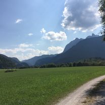
Overview
About this route
Ausgangspunkt: Talstation der Gondel in Kössen. Über Scheibenwaldhütte zur Bärenhütte. (ca. 880HM von Talstation) Dann noch ca. 200 Höhenmeter weiter auf Forsttraße. Danach zu Fuß (ca. 15-20 Minuten) zum Gipfel.
Bei der Einkehr auf der Bärenhütte sollte man darauf achten, rechtzeitig da zu sein, da nach der letzten Talfahrt (16:30), das Servicepersonal ebenfalls nach unten fährt und es nichts mehr zu essen und trinken gibt.
- -:--
- Duration
- 22.3 km
- Distance
- 1,122 m
- Ascent
- 1,118 m
- Descent
- ---
- Avg. speed
- ---
- Max. altitude

Continue with Bikemap
Use, edit, or download this cycling route
You would like to ride Unterberghorn von Kössen or customize it for your own trip? Here is what you can do with this Bikemap route:
Free features
- Save this route as favorite or in collections
- Copy & plan your own version of this route
- Sync your route with Garmin or Wahoo
Premium features
Free trial for 3 days, or one-time payment. More about Bikemap Premium.
- Navigate this route on iOS & Android
- Export a GPX / KML file of this route
- Create your custom printout (try it for free)
- Download this route for offline navigation
Discover more Premium features.
Get Bikemap PremiumFrom our community
Other popular routes starting in Kössen
 Bayr. Runde
- Distance
- 60.1 km
- Ascent
- 428 m
- Descent
- 428 m
- Location
- Kössen, Tyrol, Austria
 Kössen - Kitzbühelhorn
- Distance
- 82.9 km
- Ascent
- 1,838 m
- Descent
- 1,958 m
- Location
- Kössen, Tyrol, Austria
 Erl - Aschau - Kössen
- Distance
- 80.4 km
- Ascent
- 456 m
- Descent
- 456 m
- Location
- Kössen, Tyrol, Austria
 Zwei auf einen Schlag
- Distance
- 47.6 km
- Ascent
- 1,432 m
- Descent
- 1,432 m
- Location
- Kössen, Tyrol, Austria
 Kössen, Weißbach , Walchsee, Kössen-Runde
- Distance
- 38.3 km
- Ascent
- 960 m
- Descent
- 962 m
- Location
- Kössen, Tyrol, Austria
 Kössen - St. Johann Rundkurs
- Distance
- 43 km
- Ascent
- 771 m
- Descent
- 814 m
- Location
- Kössen, Tyrol, Austria
 Rund um den Unterberg - Kössen
- Distance
- 57.2 km
- Ascent
- 605 m
- Descent
- 570 m
- Location
- Kössen, Tyrol, Austria
 Kössen-Chiemseerunde-Kössen
- Distance
- 101.5 km
- Ascent
- 477 m
- Descent
- 477 m
- Location
- Kössen, Tyrol, Austria
Open it in the app