
Bridge Street 39, Bamber Bridge to Bridge Street 41, Bamber Bridge
A cycling route starting in Clayton-le-Woods, England, United Kingdom.
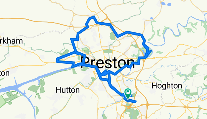
Overview
About this route
- 15 h 9 min
- Duration
- 107.6 km
- Distance
- 811 m
- Ascent
- 863 m
- Descent
- 7.1 km/h
- Avg. speed
- 95 m
- Max. altitude

Route photos

Route quality
Waytypes & surfaces along the route
Waytypes
Cycleway
52 km
(48 %)
Quiet road
33.5 km
(31 %)
Surfaces
Paved
66 km
(61 %)
Unpaved
6.1 km
(6 %)
Asphalt
52.7 km
(49 %)
Paved (undefined)
9.6 km
(9 %)
Continue with Bikemap
Use, edit, or download this cycling route
You would like to ride Bridge Street 39, Bamber Bridge to Bridge Street 41, Bamber Bridge or customize it for your own trip? Here is what you can do with this Bikemap route:
Free features
- Save this route as favorite or in collections
- Copy & plan your own version of this route
- Split it into stages to create a multi-day tour
- Sync your route with Garmin or Wahoo
Premium features
Free trial for 3 days, or one-time payment. More about Bikemap Premium.
- Navigate this route on iOS & Android
- Export a GPX / KML file of this route
- Create your custom printout (try it for free)
- Download this route for offline navigation
Discover more Premium features.
Get Bikemap PremiumFrom our community
Other popular routes starting in Clayton-le-Woods
 Bridge Street 39, Bamber Bridge to Bridge Street 41, Bamber Bridge
- Distance
- 107.6 km
- Ascent
- 811 m
- Descent
- 863 m
- Location
- Clayton-le-Woods, England, United Kingdom
 preston to knott end
- Distance
- 102.7 km
- Ascent
- 151 m
- Descent
- 151 m
- Location
- Clayton-le-Woods, England, United Kingdom
 Collins Road North 3, Bamber Bridge to Collins Road North 7, Bamber Bridge
- Distance
- 26.5 km
- Ascent
- 224 m
- Descent
- 229 m
- Location
- Clayton-le-Woods, England, United Kingdom
 Knott End training Loop
- Distance
- 88 km
- Ascent
- 131 m
- Descent
- 130 m
- Location
- Clayton-le-Woods, England, United Kingdom
 monster roundtrip
- Distance
- 139.2 km
- Ascent
- 469 m
- Descent
- 469 m
- Location
- Clayton-le-Woods, England, United Kingdom
 Leyland Flat Pancake Ride
- Distance
- 65.1 km
- Ascent
- 120 m
- Descent
- 120 m
- Location
- Clayton-le-Woods, England, United Kingdom
 23 Shaw Brow, Chorley to Waterhouse Green, 25 Shaw Brow, Chorley
- Distance
- 24.4 km
- Ascent
- 341 m
- Descent
- 341 m
- Location
- Clayton-le-Woods, England, United Kingdom
 Cuerden Valley Park
- Distance
- 5.2 km
- Ascent
- 24 m
- Descent
- 33 m
- Location
- Clayton-le-Woods, England, United Kingdom
Open it in the app