
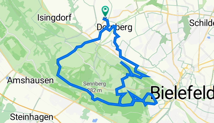
Babenhauser Straße 226, Bielefeld nach Babenhauser Straße 226, Bielefeld
A cycling route starting in Werther, North Rhine-Westphalia, Germany.
Overview
About this route
- 1 h 40 min
- Duration
- 27 km
- Distance
- 561 m
- Ascent
- 562 m
- Descent
- 16.2 km/h
- Avg. speed
- 303 m
- Max. altitude

Route quality
Waytypes & surfaces along the route
Waytypes
Track
16.1 km
(59 %)
Quiet road
3.8 km
(14 %)
Surfaces
Paved
3.9 km
(15 %)
Unpaved
15.3 km
(57 %)
Gravel
9.6 km
(36 %)
Ground
4 km
(15 %)
Continue with Bikemap
Use, edit, or download this cycling route
You would like to ride Babenhauser Straße 226, Bielefeld nach Babenhauser Straße 226, Bielefeld or customize it for your own trip? Here is what you can do with this Bikemap route:
Free features
- Save this route as favorite or in collections
- Copy & plan your own version of this route
- Sync your route with Garmin or Wahoo
Premium features
Free trial for 3 days, or one-time payment. More about Bikemap Premium.
- Navigate this route on iOS & Android
- Export a GPX / KML file of this route
- Create your custom printout (try it for free)
- Download this route for offline navigation
Discover more Premium features.
Get Bikemap PremiumFrom our community
Other popular routes starting in Werther
 1. sonnige Ausfahrt 2008
- Distance
- 42.9 km
- Ascent
- 263 m
- Descent
- 243 m
- Location
- Werther, North Rhine-Westphalia, Germany
 Beautifil Road from Halle to Bielefeld
- Distance
- 10.8 km
- Ascent
- 297 m
- Descent
- 330 m
- Location
- Werther, North Rhine-Westphalia, Germany
 2008/09_Von Häger zum Beutling
- Distance
- 38.3 km
- Ascent
- 434 m
- Descent
- 434 m
- Location
- Werther, North Rhine-Westphalia, Germany
 Bifurkation und Funkfeuer
- Distance
- 60.8 km
- Ascent
- 442 m
- Descent
- 426 m
- Location
- Werther, North Rhine-Westphalia, Germany
 Nachtradeln Bifurkation-Else-Werre mit Anfahrt und wieder zurück nach Deppendorf (Bielefeld)
- Distance
- 123.6 km
- Ascent
- 370 m
- Descent
- 370 m
- Location
- Werther, North Rhine-Westphalia, Germany
 Route im Schneckentempo in Werther (Westfalen)
- Distance
- 18.5 km
- Ascent
- 213 m
- Descent
- 216 m
- Location
- Werther, North Rhine-Westphalia, Germany
 Tour zu den drei "Zwillingswindrädern" im Ravensberger Hügelland mit Fotos
- Distance
- 46 km
- Ascent
- 348 m
- Descent
- 329 m
- Location
- Werther, North Rhine-Westphalia, Germany
 Von Werther zum Griechen Lindos
- Distance
- 19.2 km
- Ascent
- 100 m
- Descent
- 101 m
- Location
- Werther, North Rhine-Westphalia, Germany
Open it in the app