

Zacisze, Leśna a pl Ratuszowy 58, Jelenia Gora
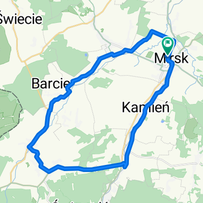
A cycling route starting in Mirsk, Lower Silesian Voivodeship, Poland.
Overview
About this route
- 4 h 21 min
- Duration
- 58.5 km
- Distance
- 791 m
- Ascent
- 797 m
- Descent
- 13.4 km/h
- Avg. speed
- 805 m
- Max. altitude

Route quality
Waytypes & surfaces along the route
Waytypes
Busy road
17.8 km
(31 %)
Quiet road
17.5 km
(30 %)
Surfaces
Paved
39.2 km
(67 %)
Unpaved
4.7 km
(8 %)
Asphalt
37.8 km
(65 %)
Unpaved (undefined)
2.4 km
(4 %)
Continue with Bikemap
Use, edit, or download this cycling route
You would like to ride Zacisze, Leśna a pl Ratuszowy 58, Jelenia Gora or customize it for your own trip? Here is what you can do with this Bikemap route:
Free features
- Save this route as favorite or in collections
- Copy & plan your own version of this route
- Sync your route with Garmin or Wahoo
Premium features
Free trial for 3 days, or one-time payment. More about Bikemap Premium.
- Navigate this route on iOS & Android
- Export a GPX / KML file of this route
- Create your custom printout (try it for free)
- Download this route for offline navigation
Discover more Premium features.
Get Bikemap PremiumFrom our community
Other popular routes starting in Mirsk
 Zacisze 13, Leśna a 11 Listopada 40, Świeradów-Zdrój
- Distance
- 13.3 km
- Ascent
- 226 m
- Descent
- 112 m
- Location
- Mirsk, Lower Silesian Voivodeship, Poland
 Zacisze 13, Leśna a pl Ks Kard Stefana Wyszyńskiego 45, Jelenia Gora
- Distance
- 58.2 km
- Ascent
- 958 m
- Descent
- 975 m
- Location
- Mirsk, Lower Silesian Voivodeship, Poland
 Przecznica 51, Mirsk do T Kościuszki 2B, Świeradów-Zdrój
- Distance
- 11.5 km
- Ascent
- 140 m
- Descent
- 601 m
- Location
- Mirsk, Lower Silesian Voivodeship, Poland
 Mlądz do Mlądz
- Distance
- 19.9 km
- Ascent
- 210 m
- Descent
- 246 m
- Location
- Mirsk, Lower Silesian Voivodeship, Poland
 Bohaterów znad Nysy 7, Mirsk do Podkolejowa 3, Mirsk
- Distance
- 22.3 km
- Ascent
- 274 m
- Descent
- 235 m
- Location
- Mirsk, Lower Silesian Voivodeship, Poland
 Sobieszow Loop
- Distance
- 52.4 km
- Ascent
- 433 m
- Descent
- 433 m
- Location
- Mirsk, Lower Silesian Voivodeship, Poland
 Przecznica 51, Mirsk do Krobica, Mirsk
- Distance
- 17 km
- Ascent
- 704 m
- Descent
- 290 m
- Location
- Mirsk, Lower Silesian Voivodeship, Poland
 Przecznica 51, Mirsk do Krobica, Mirsk
- Distance
- 30.3 km
- Ascent
- 28,012 m
- Descent
- 27,630 m
- Location
- Mirsk, Lower Silesian Voivodeship, Poland
Open it in the app