

WE juin 2023
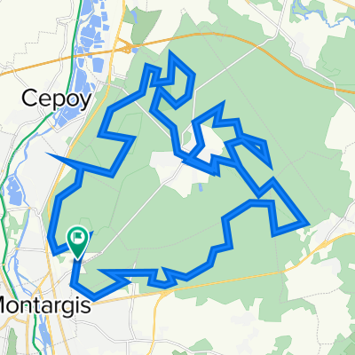
A cycling route starting in Montargis, Centre-Val de Loire, France.
Overview
About this route
- -:--
- Duration
- 229.2 km
- Distance
- 1,177 m
- Ascent
- 1,149 m
- Descent
- ---
- Avg. speed
- 415 m
- Max. altitude

Route quality
Waytypes & surfaces along the route
Waytypes
Quiet road
66.5 km
(29 %)
Cycleway
55 km
(24 %)
Surfaces
Paved
107.7 km
(47 %)
Unpaved
29.8 km
(13 %)
Asphalt
105.4 km
(46 %)
Ground
20.6 km
(9 %)
Continue with Bikemap
Use, edit, or download this cycling route
You would like to ride WE juin 2023 or customize it for your own trip? Here is what you can do with this Bikemap route:
Free features
- Save this route as favorite or in collections
- Copy & plan your own version of this route
- Split it into stages to create a multi-day tour
- Sync your route with Garmin or Wahoo
Premium features
Free trial for 3 days, or one-time payment. More about Bikemap Premium.
- Navigate this route on iOS & Android
- Export a GPX / KML file of this route
- Create your custom printout (try it for free)
- Download this route for offline navigation
Discover more Premium features.
Get Bikemap PremiumFrom our community
Other popular routes starting in Montargis
 WE juin 2023
- Distance
- 229.2 km
- Ascent
- 1,177 m
- Descent
- 1,149 m
- Location
- Montargis, Centre-Val de Loire, France
 Tour 9 maggio
- Distance
- 56.8 km
- Ascent
- 245 m
- Descent
- 298 m
- Location
- Montargis, Centre-Val de Loire, France
 4 Rue Dorée, Montargis à Rue Jean Laurent, Montargis
- Distance
- 2.8 km
- Ascent
- 7 m
- Descent
- 3 m
- Location
- Montargis, Centre-Val de Loire, France
 Randonnée des dindes à Montargis
- Distance
- 47.7 km
- Ascent
- 0 m
- Descent
- 0 m
- Location
- Montargis, Centre-Val de Loire, France
 Etapa 022C (Montargis - París)
- Distance
- 150.5 km
- Ascent
- 548 m
- Descent
- 573 m
- Location
- Montargis, Centre-Val de Loire, France
 7 Tag Montargis - Orleans
- Distance
- 73.5 km
- Ascent
- 108 m
- Descent
- 78 m
- Location
- Montargis, Centre-Val de Loire, France
 fadat 3
- Distance
- 234.9 km
- Ascent
- 658 m
- Descent
- 418 m
- Location
- Montargis, Centre-Val de Loire, France
 De Avenue Louis Maurice Chautemps à Rue du Pont Bouchet
- Distance
- 93.9 km
- Ascent
- 176 m
- Descent
- 220 m
- Location
- Montargis, Centre-Val de Loire, France
Open it in the app