

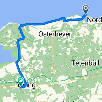
Rundtour Leuchtturm Westerheversand
A cycling route starting in Osterhever, Schleswig-Holstein, Germany.
Overview
About this route
The starting point is ideal for parking, even with large vehicles. As is common by the sea, one should not underestimate the wind! The 5 km can quickly become a long-distance ride if the wind direction is unfavorable. On the route along the dike, numerous gates must be opened and closed, breaking the monotony. Also, along the dike, the tire gets decorated with small black pellets (droppings). Unfortunately, ice cream lovers are somewhat neglected throughout the tour. In Westerhever, a village inn invites you to refuel. However, you get the ice cream at the end of the tour if you take a short stretch towards the L310, turn right, and find a snack bar just beyond the curve to end the day. On weekends, several photo tourists frequent the lighthouse area, which slightly restricts the otherwise undisturbed free ride. It is also suitable for children (from 9 years old) despite the length, as there is always something to observe. Don’t forget binoculars and naturally something against thirst. Important: in summer, definitely bring a towel to dry your feet after a mudflat hiking break.
Have fun!
- -:--
- Duration
- 30.6 km
- Distance
- 0 m
- Ascent
- 0 m
- Descent
- ---
- Avg. speed
- ---
- Max. altitude

Continue with Bikemap
Use, edit, or download this cycling route
You would like to ride Rundtour Leuchtturm Westerheversand or customize it for your own trip? Here is what you can do with this Bikemap route:
Free features
- Save this route as favorite or in collections
- Copy & plan your own version of this route
- Sync your route with Garmin or Wahoo
Premium features
Free trial for 3 days, or one-time payment. More about Bikemap Premium.
- Navigate this route on iOS & Android
- Export a GPX / KML file of this route
- Create your custom printout (try it for free)
- Download this route for offline navigation
Discover more Premium features.
Get Bikemap PremiumFrom our community
Other popular routes starting in Osterhever
 Everschoper Straße 1, Tetenbüll nach Martendorf 4, Tating
- Distance
- 20 km
- Ascent
- 41 m
- Descent
- 46 m
- Location
- Osterhever, Schleswig-Holstein, Germany
 Ording Strand
- Distance
- 20 km
- Ascent
- 4 m
- Descent
- 0 m
- Location
- Osterhever, Schleswig-Holstein, Germany
 Westerhever Leuchtturm, St.P.Ording
- Distance
- 58.4 km
- Ascent
- 15 m
- Descent
- 18 m
- Location
- Osterhever, Schleswig-Holstein, Germany
 Tönning, Friedrichstadt
- Distance
- 56.6 km
- Ascent
- 9 m
- Descent
- 12 m
- Location
- Osterhever, Schleswig-Holstein, Germany
 Etappe 3 Tetenbüllspieker bis Bredstedt
- Distance
- 78.8 km
- Ascent
- 14 m
- Descent
- 14 m
- Location
- Osterhever, Schleswig-Holstein, Germany
 Everschopsiel 1, Tetenbüll nach Poggenburgstraße 12, Husum
- Distance
- 21.5 km
- Ascent
- 427 m
- Descent
- 422 m
- Location
- Osterhever, Schleswig-Holstein, Germany
 Osterhever 5,5km Laufstrecke
- Distance
- 5.5 km
- Ascent
- 4 m
- Descent
- 4 m
- Location
- Osterhever, Schleswig-Holstein, Germany
 Everschoper Straße 1, Tetenbüll nach Wogemannsweg 7, Sankt-Peter-Ording
- Distance
- 21.1 km
- Ascent
- 34 m
- Descent
- 35 m
- Location
- Osterhever, Schleswig-Holstein, Germany
Open it in the app