

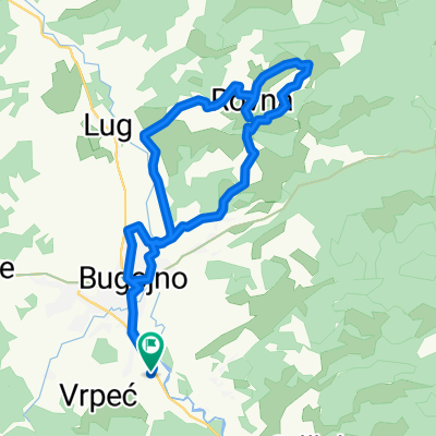
Kupres-Stožer-Plazenica
A cycling route starting in Bugojno, Federation of Bosnia and Herzegovina, Bosnia and Herzegovina.
Overview
About this route
- -:--
- Duration
- 28.2 km
- Distance
- 877 m
- Ascent
- 873 m
- Descent
- ---
- Avg. speed
- ---
- Max. altitude

Route highlights
Points of interest along the route
Point of interest after 16.1 km
Stožer 1758n/m
Point of interest after 25.2 km
Perin izvor
Continue with Bikemap
Use, edit, or download this cycling route
You would like to ride Kupres-Stožer-Plazenica or customize it for your own trip? Here is what you can do with this Bikemap route:
Free features
- Save this route as favorite or in collections
- Copy & plan your own version of this route
- Sync your route with Garmin or Wahoo
Premium features
Free trial for 3 days, or one-time payment. More about Bikemap Premium.
- Navigate this route on iOS & Android
- Export a GPX / KML file of this route
- Create your custom printout (try it for free)
- Download this route for offline navigation
Discover more Premium features.
Get Bikemap PremiumFrom our community
Other popular routes starting in Bugojno
 Bugojno - Brela
- Distance
- 150 km
- Ascent
- 1,327 m
- Descent
- 1,909 m
- Location
- Bugojno, Federation of Bosnia and Herzegovina, Bosnia and Herzegovina
 Recording from 09. novembar 14:02
- Distance
- 28.4 km
- Ascent
- 466 m
- Descent
- 468 m
- Location
- Bugojno, Federation of Bosnia and Herzegovina, Bosnia and Herzegovina
 Recording from 27. oktobar 14:23
- Distance
- 24.4 km
- Ascent
- 164 m
- Descent
- 161 m
- Location
- Bugojno, Federation of Bosnia and Herzegovina, Bosnia and Herzegovina
 Kupres-Stožer-Plazenica
- Distance
- 28.2 km
- Ascent
- 877 m
- Descent
- 873 m
- Location
- Bugojno, Federation of Bosnia and Herzegovina, Bosnia and Herzegovina
 Bugojno-Podgora
- Distance
- 159.9 km
- Ascent
- 1,320 m
- Descent
- 1,903 m
- Location
- Bugojno, Federation of Bosnia and Herzegovina, Bosnia and Herzegovina
 Bugojno - Livno - Glamoč - Jajce - Bugojno
- Distance
- 230.9 km
- Ascent
- 1,974 m
- Descent
- 1,974 m
- Location
- Bugojno, Federation of Bosnia and Herzegovina, Bosnia and Herzegovina
 Bosnia trip from 2013
- Distance
- 183.4 km
- Ascent
- 1,076 m
- Descent
- 2,251 m
- Location
- Bugojno, Federation of Bosnia and Herzegovina, Bosnia and Herzegovina
 Recording from 18. septembar 11:04
- Distance
- 31.2 km
- Ascent
- 350 m
- Descent
- 352 m
- Location
- Bugojno, Federation of Bosnia and Herzegovina, Bosnia and Herzegovina
Open it in the app