

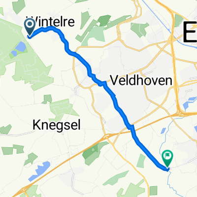
Van Jaap en Erna naar VV14
A cycling route starting in Oerle, North Brabant, The Netherlands.
Overview
About this route
Niet de allerkortste, wel met minste stoplichten
- -:--
- Duration
- 16.3 km
- Distance
- 22 m
- Ascent
- 25 m
- Descent
- ---
- Avg. speed
- 27 m
- Max. altitude
Route quality
Waytypes & surfaces along the route
Waytypes
Cycleway
11.7 km
(72 %)
Quiet road
2.1 km
(13 %)
Surfaces
Paved
7.8 km
(48 %)
Asphalt
7.8 km
(48 %)
Undefined
8.5 km
(52 %)
Continue with Bikemap
Use, edit, or download this cycling route
You would like to ride Van Jaap en Erna naar VV14 or customize it for your own trip? Here is what you can do with this Bikemap route:
Free features
- Save this route as favorite or in collections
- Copy & plan your own version of this route
- Sync your route with Garmin or Wahoo
Premium features
Free trial for 3 days, or one-time payment. More about Bikemap Premium.
- Navigate this route on iOS & Android
- Export a GPX / KML file of this route
- Create your custom printout (try it for free)
- Download this route for offline navigation
Discover more Premium features.
Get Bikemap PremiumFrom our community
Other popular routes starting in Oerle
 Van Jaap en Erna naar VV14
- Distance
- 16.3 km
- Ascent
- 22 m
- Descent
- 25 m
- Location
- Oerle, North Brabant, The Netherlands
 bosschuur Wintelre
- Distance
- 34 km
- Ascent
- 58 m
- Descent
- 60 m
- Location
- Oerle, North Brabant, The Netherlands
 Rondje Eindhoven Airport
- Distance
- 12.9 km
- Ascent
- 12 m
- Descent
- 12 m
- Location
- Oerle, North Brabant, The Netherlands
 Frankrijk Wintelre Bergen (mons)
- Distance
- 184 km
- Ascent
- 345 m
- Descent
- 302 m
- Location
- Oerle, North Brabant, The Netherlands
 Vanaf Veldhoven 64 km
- Distance
- 63.1 km
- Ascent
- 105 m
- Descent
- 110 m
- Location
- Oerle, North Brabant, The Netherlands
 Merenweg 1, Wintelre naar Volmolenweg 1, Riethoven
- Distance
- 11 km
- Ascent
- 10 m
- Descent
- 16 m
- Location
- Oerle, North Brabant, The Netherlands
 Bij Vessem linksaf (fietsroute: 181581) - route.nl
- Distance
- 50.3 km
- Ascent
- 64 m
- Descent
- 67 m
- Location
- Oerle, North Brabant, The Netherlands
 Brabants Landschapsroute
- Distance
- 125.2 km
- Ascent
- 61 m
- Descent
- 59 m
- Location
- Oerle, North Brabant, The Netherlands
Open it in the app