

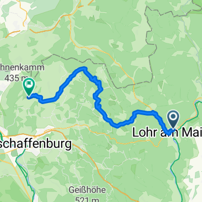
Lohr - Forsthäuser Tour - Hafenlohr - Lohr
A cycling route starting in Lohr a. Main, Bavaria, Germany.
Overview
About this route
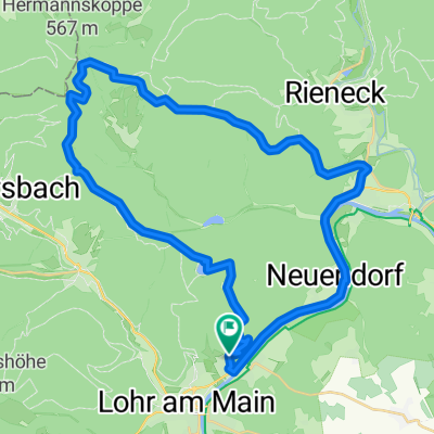
abwechslungsreiche MTB-Tour mit mäßigen und auch knackigen (16% max.) Steigungen, aber auch flotten Abfahrten.
Anlaufpunkte: Margarethenhof - Forsthaus Aurora(bewirtet) - Forsthaus Diana - Einsiedel - Sylvan (bewirtet) - Karlshöhe bewirtet) - Faunmühle - Wndheim (Zeltplatz) - Hafenlohr - Neustadt - Erlach.
Rast bei Toni (Maintalhof bewirtet)
zurück über Pflochsbach nach Lohr Mainlände
ca. 1000 hm
- -:--
- Duration
- 65.9 km
- Distance
- 842 m
- Ascent
- 841 m
- Descent
- ---
- Avg. speed
- ---
- Max. altitude

Route highlights
Points of interest along the route
Point of interest after 16.7 km
Forsthaus Aurora
Point of interest after 30.1 km
Forsthaus Sylvan
Point of interest after 36.1 km
lohnende Rastmöglichkeit
Point of interest after 56.3 km
Maintalhof; Hofcafe und Biergarten bei Toni Fleckenstein
Point of interest after 56.3 km
Continue with Bikemap
Use, edit, or download this cycling route
You would like to ride Lohr - Forsthäuser Tour - Hafenlohr - Lohr or customize it for your own trip? Here is what you can do with this Bikemap route:
Free features
- Save this route as favorite or in collections
- Copy & plan your own version of this route
- Sync your route with Garmin or Wahoo
Premium features
Free trial for 3 days, or one-time payment. More about Bikemap Premium.
- Navigate this route on iOS & Android
- Export a GPX / KML file of this route
- Create your custom printout (try it for free)
- Download this route for offline navigation
Discover more Premium features.
Get Bikemap PremiumFrom our community
Other popular routes starting in Lohr a. Main
 Ausfahrt durch Lohr am Main
- Distance
- 27.1 km
- Ascent
- 364 m
- Descent
- 367 m
- Location
- Lohr a. Main, Bavaria, Germany
 Lohr-Maintal-Platte
- Distance
- 33.4 km
- Ascent
- 345 m
- Descent
- 246 m
- Location
- Lohr a. Main, Bavaria, Germany
 1ter Tag Lohr Mömbris
- Distance
- 56.5 km
- Ascent
- 542 m
- Descent
- 483 m
- Location
- Lohr a. Main, Bavaria, Germany
 Lohr - Forsthäuser Tour - Hafenlohr - Lohr
- Distance
- 65.9 km
- Ascent
- 842 m
- Descent
- 841 m
- Location
- Lohr a. Main, Bavaria, Germany
 The Fog
- Distance
- 41 km
- Ascent
- 683 m
- Descent
- 683 m
- Location
- Lohr a. Main, Bavaria, Germany
 Lohr - Kreuzberg
- Distance
- 83.6 km
- Ascent
- 1,518 m
- Descent
- 865 m
- Location
- Lohr a. Main, Bavaria, Germany
 Von Lohr ins Sinntal
- Distance
- 47.4 km
- Ascent
- 77 m
- Descent
- 77 m
- Location
- Lohr a. Main, Bavaria, Germany
 LohramMain
- Distance
- 127.3 km
- Ascent
- 1,717 m
- Descent
- 1,732 m
- Location
- Lohr a. Main, Bavaria, Germany
Open it in the app