

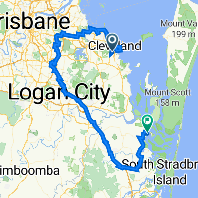
16–32 Charles Canty Drive, Ormiston to 6 Trio St, Cleveland
A cycling route starting in Cleveland, Queensland, Australia.
Overview
About this route
- 1 h 30 min
- Duration
- 14.3 km
- Distance
- 240 m
- Ascent
- 219 m
- Descent
- 9.6 km/h
- Avg. speed
- 71 m
- Max. altitude

Route quality
Waytypes & surfaces along the route
Waytypes
Quiet road
3.9 km
(27 %)
Cycleway
3.7 km
(26 %)
Surfaces
Paved
10 km
(70 %)
Unpaved
3.6 km
(25 %)
Asphalt
5.6 km
(39 %)
Concrete
4.4 km
(31 %)
Continue with Bikemap
Use, edit, or download this cycling route
You would like to ride 16–32 Charles Canty Drive, Ormiston to 6 Trio St, Cleveland or customize it for your own trip? Here is what you can do with this Bikemap route:
Free features
- Save this route as favorite or in collections
- Copy & plan your own version of this route
- Sync your route with Garmin or Wahoo
Premium features
Free trial for 3 days, or one-time payment. More about Bikemap Premium.
- Navigate this route on iOS & Android
- Export a GPX / KML file of this route
- Create your custom printout (try it for free)
- Download this route for offline navigation
Discover more Premium features.
Get Bikemap PremiumFrom our community
Other popular routes starting in Cleveland
 Daisy Hill
- Distance
- 78.7 km
- Ascent
- 422 m
- Descent
- 418 m
- Location
- Cleveland, Queensland, Australia
 SE Bikeway part 2
- Distance
- 24.8 km
- Ascent
- 66 m
- Descent
- 64 m
- Location
- Cleveland, Queensland, Australia
 Thornlands to Cleveland Point
- Distance
- 20.4 km
- Ascent
- 75 m
- Descent
- 71 m
- Location
- Cleveland, Queensland, Australia
 Shore Street West 124, Cleveland to Royal Esplanade 409, Manly
- Distance
- 18.1 km
- Ascent
- 84 m
- Descent
- 81 m
- Location
- Cleveland, Queensland, Australia
 Last Ride Before Vacation
- Distance
- 9.8 km
- Ascent
- 52 m
- Descent
- 51 m
- Location
- Cleveland, Queensland, Australia
 Wello to Toowong Village
- Distance
- 32.9 km
- Ascent
- 314 m
- Descent
- 307 m
- Location
- Cleveland, Queensland, Australia
 3 Trio St, Cleveland to 24 Warana Ave, Steiglitz
- Distance
- 110.1 km
- Ascent
- 676 m
- Descent
- 699 m
- Location
- Cleveland, Queensland, Australia
 16–32 Charles Canty Drive, Ormiston to 6 Trio St, Cleveland
- Distance
- 14.3 km
- Ascent
- 240 m
- Descent
- 219 m
- Location
- Cleveland, Queensland, Australia
Open it in the app