

12345
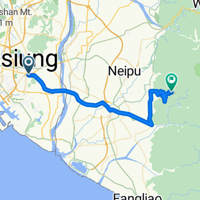
A cycling route starting in Fongshan District, Taiwan, Taiwan.
Overview
About this route
- -:--
- Duration
- 8.3 km
- Distance
- 92 m
- Ascent
- 87 m
- Descent
- ---
- Avg. speed
- 42 m
- Max. altitude

Route quality
Waytypes & surfaces along the route
Waytypes
Road
4.6 km
(55 %)
Quiet road
2.1 km
(25 %)
Continue with Bikemap
Use, edit, or download this cycling route
You would like to ride 12345 or customize it for your own trip? Here is what you can do with this Bikemap route:
Free features
- Save this route as favorite or in collections
- Copy & plan your own version of this route
- Sync your route with Garmin or Wahoo
Premium features
Free trial for 3 days, or one-time payment. More about Bikemap Premium.
- Navigate this route on iOS & Android
- Export a GPX / KML file of this route
- Create your custom printout (try it for free)
- Download this route for offline navigation
Discover more Premium features.
Get Bikemap PremiumFrom our community
Other popular routes starting in Fongshan District
 高獨第三級無料200K
- Distance
- 199.4 km
- Ascent
- 1,587 m
- Descent
- 1,586 m
- Location
- Fongshan District, Taiwan, Taiwan
 20101121第二屆水瓶座-北大武盃
- Distance
- 51.3 km
- Ascent
- 834 m
- Descent
- 96 m
- Location
- Fongshan District, Taiwan, Taiwan
 北大武車隊-黃埔公園到北大武
- Distance
- 91.8 km
- Ascent
- 721 m
- Descent
- 723 m
- Location
- Fongshan District, Taiwan, Taiwan
 中寮山輕鬆路線50公里腳力鍛鍊
- Distance
- 50.9 km
- Ascent
- 603 m
- Descent
- 594 m
- Location
- Fongshan District, Taiwan, Taiwan
 瘋400K試騎路線圖
- Distance
- 205.9 km
- Ascent
- 779 m
- Descent
- 772 m
- Location
- Fongshan District, Taiwan, Taiwan
 高獨無料200K-第一級壽卡路線(去程)
- Distance
- 100.8 km
- Ascent
- 549 m
- Descent
- 95 m
- Location
- Fongshan District, Taiwan, Taiwan
 北大武車隊-澄清湖繞圈
- Distance
- 7.5 km
- Ascent
- 111 m
- Descent
- 111 m
- Location
- Fongshan District, Taiwan, Taiwan
 北大武車隊-環保公園-旗山環線
- Distance
- 81 km
- Ascent
- 633 m
- Descent
- 626 m
- Location
- Fongshan District, Taiwan, Taiwan
Open it in the app