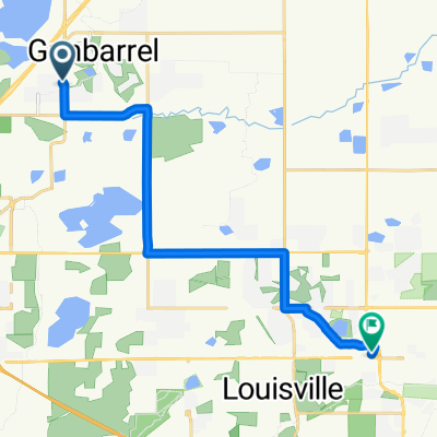
Gunbarrel to Teller Ranch, Boulder CO
A cycling route starting in Gunbarrel, Colorado, United States of America.
Overview
About this route
Mostly off road and on concrete sidewalks. 9.4 miles one direction
- -:--
- Duration
- 15.1 km
- Distance
- 187 m
- Ascent
- 198 m
- Descent
- ---
- Avg. speed
- 1,654 m
- Avg. speed
Route quality
Waytypes & surfaces along the route
Waytypes
Cycleway
13.7 km
(91 %)
Quiet road
0.6 km
(4 %)
Surfaces
Paved
0.5 km
(4 %)
Unpaved
13.8 km
(92 %)
Gravel
7.3 km
(48 %)
Loose gravel
3.4 km
(23 %)
Continue with Bikemap
Use, edit, or download this cycling route
You would like to ride Gunbarrel to Teller Ranch, Boulder CO or customize it for your own trip? Here is what you can do with this Bikemap route:
Free features
- Save this route as favorite or in collections
- Copy & plan your own version of this route
- Sync your route with Garmin or Wahoo
Premium features
Free trial for 3 days, or one-time payment. More about Bikemap Premium.
- Navigate this route on iOS & Android
- Export a GPX / KML file of this route
- Create your custom printout (try it for free)
- Download this route for offline navigation
Discover more Premium features.
Get Bikemap PremiumFrom our community
Other popular routes starting in Gunbarrel
- Boulder 48mi
- Distance
- 78.5 km
- Ascent
- 426 m
- Descent
- 429 m
- Location
- Gunbarrel, Colorado, United States of America
- Boulder Reservoir
- Distance
- 41.9 km
- Ascent
- 272 m
- Descent
- 272 m
- Location
- Gunbarrel, Colorado, United States of America
- Gunbarrel to Teller Ranch, Boulder CO
- Distance
- 15.1 km
- Ascent
- 187 m
- Descent
- 198 m
- Location
- Gunbarrel, Colorado, United States of America
- Part 1 Cycle
- Distance
- 45.4 km
- Ascent
- 426 m
- Descent
- 415 m
- Location
- Gunbarrel, Colorado, United States of America
- Avery Brewery to Left Hand Creek Park
- Distance
- 14.3 km
- Ascent
- 55 m
- Descent
- 114 m
- Location
- Gunbarrel, Colorado, United States of America
- Harvest Moon Course
- Distance
- 44.1 km
- Ascent
- 296 m
- Descent
- 272 m
- Location
- Gunbarrel, Colorado, United States of America
- Boulder IM Estimate
- Distance
- 63.5 km
- Ascent
- 552 m
- Descent
- 550 m
- Location
- Gunbarrel, Colorado, United States of America
- Ironman Boulder 2014: Bike Course
- Distance
- 180.3 km
- Ascent
- 834 m
- Descent
- 788 m
- Location
- Gunbarrel, Colorado, United States of America
Open it in the app