

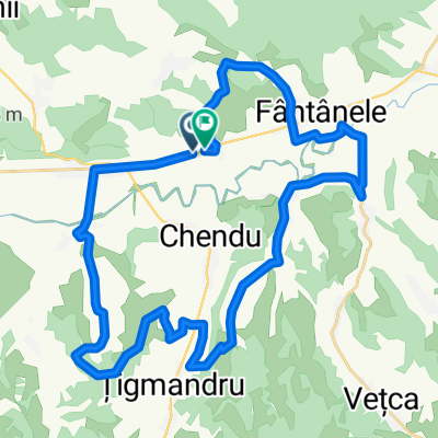
DN13A 59, Fântânele - DJ138 11, Târnovița
A cycling route starting in Fântânele, Mureș County, Romania.
Overview
About this route
null
- 11 h 21 min
- Duration
- 77.4 km
- Distance
- 677 m
- Ascent
- 499 m
- Descent
- 6.8 km/h
- Avg. speed
- 619 m
- Max. altitude

Route quality
Waytypes & surfaces along the route
Waytypes
Quiet road
22.5 km
(29 %)
Access road
0.8 km
(1 %)
Surfaces
Paved
57.3 km
(74 %)
Unpaved
12.4 km
(16 %)
Asphalt
57.3 km
(74 %)
Gravel
12.4 km
(16 %)
Undefined
7.7 km
(10 %)
Continue with Bikemap
Use, edit, or download this cycling route
You would like to ride DN13A 59, Fântânele - DJ138 11, Târnovița or customize it for your own trip? Here is what you can do with this Bikemap route:
Free features
- Save this route as favorite or in collections
- Copy & plan your own version of this route
- Sync your route with Garmin or Wahoo
Premium features
Free trial for 3 days, or one-time payment. More about Bikemap Premium.
- Navigate this route on iOS & Android
- Export a GPX / KML file of this route
- Create your custom printout (try it for free)
- Download this route for offline navigation
Discover more Premium features.
Get Bikemap PremiumFrom our community
Other popular routes starting in Fântânele
 Nándorfehérvár-Csíksomlyó VII. nap
- Distance
- 69 km
- Ascent
- 919 m
- Descent
- 745 m
- Location
- Fântânele, Mureș County, Romania
 46.413° N 24.798° W to Strada Nicolae Bălcescu 58, Sângeorgiu de Padure
- Distance
- 4 km
- Ascent
- 3 m
- Descent
- 3 m
- Location
- Fântânele, Mureș County, Romania
 DN13A 59, Fântânele - DJ138 11, Târnovița
- Distance
- 77.4 km
- Ascent
- 677 m
- Descent
- 499 m
- Location
- Fântânele, Mureș County, Romania
 DN13A 247a - DN13A 247a
- Distance
- 59.9 km
- Ascent
- 895 m
- Descent
- 893 m
- Location
- Fântânele, Mureș County, Romania
 Easy ride in
- Distance
- 5.6 km
- Ascent
- 61 m
- Descent
- 64 m
- Location
- Fântânele, Mureș County, Romania
 DN13A - DN13A
- Distance
- 35.9 km
- Ascent
- 568 m
- Descent
- 566 m
- Location
- Fântânele, Mureș County, Romania
 Sâmbătă, 6 mai 2017, la Saschiz, judeţul Mureş
- Distance
- 74.3 km
- Ascent
- 577 m
- Descent
- 569 m
- Location
- Fântânele, Mureș County, Romania
 Vécke-Magyarzsákod
- Distance
- 29.1 km
- Ascent
- 118 m
- Descent
- 117 m
- Location
- Fântânele, Mureș County, Romania
Open it in the app