

Glenmont to Kentucky
A cycling route starting in Millersburg, Ohio, United States.
Overview
About this route
- -:--
- Duration
- 326.1 km
- Distance
- 1,278 m
- Ascent
- 1,400 m
- Descent
- ---
- Avg. speed
- 389 m
- Max. altitude

Route quality
Waytypes & surfaces along the route
Waytypes
Cycleway
259.1 km
(79 %)
Quiet road
24.5 km
(8 %)
Surfaces
Paved
161.1 km
(49 %)
Unpaved
0.4 km
(<1 %)
Asphalt
119.3 km
(37 %)
Paved (undefined)
39.3 km
(12 %)
Continue with Bikemap
Use, edit, or download this cycling route
You would like to ride Glenmont to Kentucky or customize it for your own trip? Here is what you can do with this Bikemap route:
Free features
- Save this route as favorite or in collections
- Copy & plan your own version of this route
- Split it into stages to create a multi-day tour
- Sync your route with Garmin or Wahoo
Premium features
Free trial for 3 days, or one-time payment. More about Bikemap Premium.
- Navigate this route on iOS & Android
- Export a GPX / KML file of this route
- Create your custom printout (try it for free)
- Download this route for offline navigation
Discover more Premium features.
Get Bikemap PremiumFrom our community
Other popular routes starting in Millersburg
 6 N Washington St, Millersburg to 701–899 Trailwood Dr, Boardman
- Distance
- 152.5 km
- Ascent
- 986 m
- Descent
- 930 m
- Location
- Millersburg, Ohio, United States
 Nashville Loop
- Distance
- 48.2 km
- Ascent
- 563 m
- Descent
- 562 m
- Location
- Millersburg, Ohio, United States
 Ohio to Erie central north
- Distance
- 137.9 km
- Ascent
- 283 m
- Descent
- 289 m
- Location
- Millersburg, Ohio, United States
 OTET_NB_North
- Distance
- 182.5 km
- Ascent
- 946 m
- Descent
- 1,018 m
- Location
- Millersburg, Ohio, United States
 Nashville
- Distance
- 56.9 km
- Ascent
- 340 m
- Descent
- 342 m
- Location
- Millersburg, Ohio, United States
 day 3 otet
- Distance
- 119.5 km
- Ascent
- 397 m
- Descent
- 376 m
- Location
- Millersburg, Ohio, United States
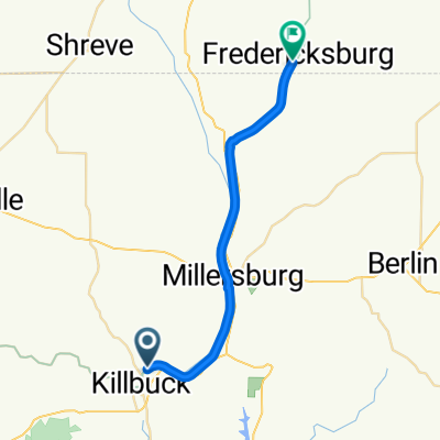 N Main St, Killbuck to W Clay St, Fredericksburg
- Distance
- 25.4 km
- Ascent
- 136 m
- Descent
- 86 m
- Location
- Millersburg, Ohio, United States
 60 on Ohio Erie Trail
- Distance
- 96.3 km
- Ascent
- 268 m
- Descent
- 259 m
- Location
- Millersburg, Ohio, United States
Open it in the app