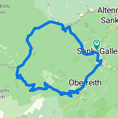
2023_05_27_Hintergebirge
A cycling route starting in Sankt Gallen, Styria, Austria.
Overview
About this route
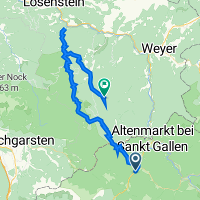
Mooshöhe-Blaabergalm-Reichraming-GH.Damhofer (Knoblauchforelle)-Wendbach Hausbach-Molln
- -:--
- Duration
- 77 km
- Distance
- 2,498 m
- Ascent
- 2,580 m
- Descent
- ---
- Avg. speed
- 1,052 m
- Max. altitude
Route quality
Waytypes & surfaces along the route
Waytypes
Track
43.1 km
(56 %)
Quiet road
18.5 km
(24 %)
Surfaces
Paved
10 km
(13 %)
Unpaved
47 km
(61 %)
Gravel
42.3 km
(55 %)
Asphalt
6.2 km
(8 %)
Continue with Bikemap
Use, edit, or download this cycling route
You would like to ride 2023_05_27_Hintergebirge or customize it for your own trip? Here is what you can do with this Bikemap route:
Free features
- Save this route as favorite or in collections
- Copy & plan your own version of this route
- Sync your route with Garmin or Wahoo
Premium features
Free trial for 3 days, or one-time payment. More about Bikemap Premium.
- Navigate this route on iOS & Android
- Export a GPX / KML file of this route
- Create your custom printout (try it for free)
- Download this route for offline navigation
Discover more Premium features.
Get Bikemap PremiumFrom our community
Other popular routes starting in Sankt Gallen
- Kolem národního parku
- Distance
- 56.5 km
- Ascent
- 1,460 m
- Descent
- 1,400 m
- Location
- Sankt Gallen, Styria, Austria
- B117 36, Sankt Gallen nach Am Ortsplatz 1, Reichraming
- Distance
- 38.1 km
- Ascent
- 918 m
- Descent
- 1,076 m
- Location
- Sankt Gallen, Styria, Austria
- Hintergeb. Var. 1
- Distance
- 69.5 km
- Ascent
- 1,333 m
- Descent
- 1,981 m
- Location
- Sankt Gallen, Styria, Austria
- Bodenweg 39, St. Gallen nach Lumpelgraben, Großraming
- Distance
- 57.8 km
- Ascent
- 1,684 m
- Descent
- 1,451 m
- Location
- Sankt Gallen, Styria, Austria
- 2024_08_30_St.Gallen-Molln
- Distance
- 52.4 km
- Ascent
- 2,814 m
- Descent
- 2,859 m
- Location
- Sankt Gallen, Styria, Austria
- Sankt Gallen - Großraming - Brunnbach - Reichraming
- Distance
- 56.5 km
- Ascent
- 557 m
- Descent
- 710 m
- Location
- Sankt Gallen, Styria, Austria
- Buchsteinrunde Ennstal
- Distance
- 122.8 km
- Ascent
- 2,622 m
- Descent
- 2,625 m
- Location
- Sankt Gallen, Styria, Austria
- 2023_05_27_Hintergebirge
- Distance
- 77 km
- Ascent
- 2,498 m
- Descent
- 2,580 m
- Location
- Sankt Gallen, Styria, Austria
Open it in the app