

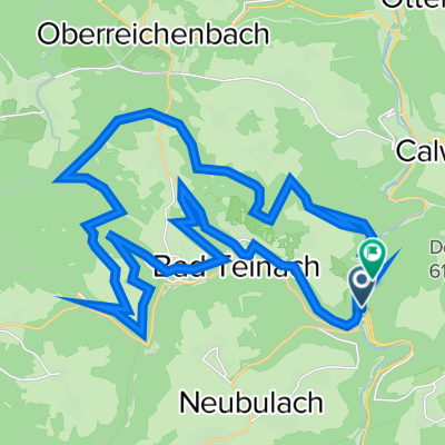
Wildberg-Kuppingen-Zavelstein
A cycling route starting in Bad Teinach-Zavelstein, Baden-Wurttemberg, Germany.
Overview
About this route
Gut fahrbare Mountain Bike Tour mit teilweise asphaltierten, teilweise befestigten Wegen (alles 2-spurig). Gleichmäßig verteilte Steigungen.
- -:--
- Duration
- 69.4 km
- Distance
- 756 m
- Ascent
- 756 m
- Descent
- ---
- Avg. speed
- ---
- Max. altitude
Continue with Bikemap
Use, edit, or download this cycling route
You would like to ride Wildberg-Kuppingen-Zavelstein or customize it for your own trip? Here is what you can do with this Bikemap route:
Free features
- Save this route as favorite or in collections
- Copy & plan your own version of this route
- Sync your route with Garmin or Wahoo
Premium features
Free trial for 3 days, or one-time payment. More about Bikemap Premium.
- Navigate this route on iOS & Android
- Export a GPX / KML file of this route
- Create your custom printout (try it for free)
- Download this route for offline navigation
Discover more Premium features.
Get Bikemap PremiumFrom our community
Other popular routes starting in Bad Teinach-Zavelstein
 Krokusstraße 22, Bad Teinach-Zavelstein nach Graf-Eberhard-Straße 4, Bad Teinach-Zavelstein
- Distance
- 35.2 km
- Ascent
- 559 m
- Descent
- 537 m
- Location
- Bad Teinach-Zavelstein, Baden-Wurttemberg, Germany
 Wildberg-Kuppingen-Zavelstein
- Distance
- 69.4 km
- Ascent
- 756 m
- Descent
- 756 m
- Location
- Bad Teinach-Zavelstein, Baden-Wurttemberg, Germany
 Otto-Neidhart-Allee 5, Bad Teinach-Zavelstein nach Otto-Neidhart-Allee 5, Bad Teinach-Zavelstein
- Distance
- 45.4 km
- Ascent
- 1,875 m
- Descent
- 1,875 m
- Location
- Bad Teinach-Zavelstein, Baden-Wurttemberg, Germany
 Nagoldtal-Radtour
- Distance
- 33.9 km
- Ascent
- 246 m
- Descent
- 316 m
- Location
- Bad Teinach-Zavelstein, Baden-Wurttemberg, Germany
 Nord Schwarzwald - Bonn
- Distance
- 394 km
- Ascent
- 605 m
- Descent
- 1,111 m
- Location
- Bad Teinach-Zavelstein, Baden-Wurttemberg, Germany
 Rötenbach-Altburg-Calw-Lützenhardt-Rötenbach
- Distance
- 22.7 km
- Ascent
- 356 m
- Descent
- 355 m
- Location
- Bad Teinach-Zavelstein, Baden-Wurttemberg, Germany
 Rundfahrt: Teinach - Atensteig - Nagoldtasperre...
- Distance
- 94.3 km
- Ascent
- 805 m
- Descent
- 805 m
- Location
- Bad Teinach-Zavelstein, Baden-Wurttemberg, Germany
 Schluchtenweg-Tour
- Distance
- 33.8 km
- Ascent
- 637 m
- Descent
- 583 m
- Location
- Bad Teinach-Zavelstein, Baden-Wurttemberg, Germany
Open it in the app