

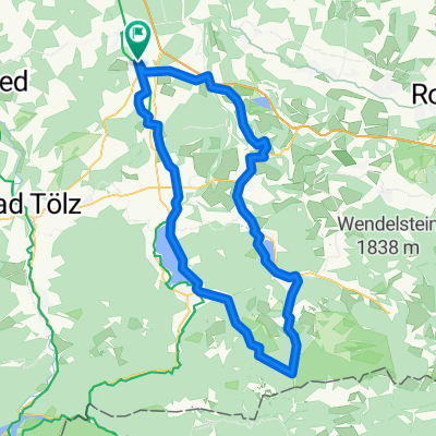
Holzkirchen-Gmund über M-Wasserweg zurück
A cycling route starting in Holzkirchen, Bavaria, Germany.
Overview
About this route
- 3 h 41 min
- Duration
- 49.8 km
- Distance
- 613 m
- Ascent
- 609 m
- Descent
- 13.5 km/h
- Avg. speed
- 782 m
- Avg. speed

Route photos

Route quality
Waytypes & surfaces along the route
Waytypes
Quiet road
27.5 km
(55 %)
Track
8.6 km
(17 %)
Surfaces
Paved
40.9 km
(82 %)
Unpaved
7.6 km
(15 %)
Asphalt
40.3 km
(81 %)
Gravel
5 km
(10 %)
Continue with Bikemap
Use, edit, or download this cycling route
You would like to ride Holzkirchen-Gmund über M-Wasserweg zurück or customize it for your own trip? Here is what you can do with this Bikemap route:
Free features
- Save this route as favorite or in collections
- Copy & plan your own version of this route
- Sync your route with Garmin or Wahoo
Premium features
Free trial for 3 days, or one-time payment. More about Bikemap Premium.
- Navigate this route on iOS & Android
- Export a GPX / KML file of this route
- Create your custom printout (try it for free)
- Download this route for offline navigation
Discover more Premium features.
Get Bikemap PremiumFrom our community
Other popular routes starting in Holzkirchen
 Holzkirchen-Tegernsee
- Distance
- 18.8 km
- Ascent
- 189 m
- Descent
- 129 m
- Location
- Holzkirchen, Bavaria, Germany
 Feierabendrunde Hoki-Kirchsee-Bairawies-Hoki
- Distance
- 43.3 km
- Ascent
- 405 m
- Descent
- 394 m
- Location
- Holzkirchen, Bavaria, Germany
 Holzkirchen nach Miesbach Krauthof Café über Höfe zurück
- Distance
- 45.7 km
- Ascent
- 528 m
- Descent
- 528 m
- Location
- Holzkirchen, Bavaria, Germany
 Marktplatz Holzkirchen nach Gmund, Holzkirchen
- Distance
- 39.1 km
- Ascent
- 784 m
- Descent
- 786 m
- Location
- Holzkirchen, Bavaria, Germany
 Holzkirchen Bahnhof - Bad Tölz - Holzkirchen Bahnhof
- Distance
- 53.5 km
- Ascent
- 650 m
- Descent
- 628 m
- Location
- Holzkirchen, Bavaria, Germany
 Holzkirchen nach Miesbach Krauthof Café über Höfe zurück
- Distance
- 46.5 km
- Ascent
- 781 m
- Descent
- 779 m
- Location
- Holzkirchen, Bavaria, Germany
 Hoki Tegernsee Valepp
- Distance
- 84.8 km
- Ascent
- 756 m
- Descent
- 755 m
- Location
- Holzkirchen, Bavaria, Germany
 Holzkirchen-Schlier-Spitzing-Tegernsee
- Distance
- 88 km
- Ascent
- 820 m
- Descent
- 819 m
- Location
- Holzkirchen, Bavaria, Germany
Open it in the app