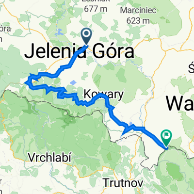
Jelenia G贸ra - Janowice Wielkie - Jelenia G贸ra
A cycling route starting in Je偶贸w Sudecki, Lower Silesian Voivodeship, Poland.
Overview
About this route
艁agodna trasa przebiegaj膮ca w du偶ej cz臋艣ci wzd艂贸偶 rzeki B贸br.
Mijane miejscowo艣ci to: D膮browica, Wojan贸w, Trzci艅sko, Janowice Wielkie.
Wi臋ksza cz臋艣膰 trasy przebiega asfaltowymi, ma艂o ruchliwymi drogami.
- -:--
- Duration
- 37.4 km
- Distance
- 161 m
- Ascent
- 163 m
- Descent
- ---
- Avg. speed
- ---
- Avg. speed
Continue with Bikemap
Use, edit, or download this cycling route
You would like to ride Jelenia G贸ra - Janowice Wielkie - Jelenia G贸ra or customize it for your own trip? Here is what you can do with this Bikemap route:
Free features
- Save this route as favorite or in collections
- Copy & plan your own version of this route
- Sync your route with Garmin or Wahoo
Premium features
Free trial for 3 days, or one-time payment. More about Bikemap Premium.
- Navigate this route on iOS & Android
- Export a GPX / KML file of this route
- Create your custom printout (try it for free)
- Download this route for offline navigation
Discover more Premium features.
Get Bikemap PremiumFrom our community
Other popular routes starting in Je偶贸w Sudecki
- JG-Zapora_Wojciechow_Barcinek_JG
- Distance
- 47.1 km
- Ascent
- 374 m
- Descent
- 377 m
- Location
- Je偶贸w Sudecki, Lower Silesian Voivodeship, Poland
- Sportowa trasa w Jelenia G贸ra
- Distance
- 36.4 km
- Ascent
- 273 m
- Descent
- 267 m
- Location
- Je偶贸w Sudecki, Lower Silesian Voivodeship, Poland
- Dzie艅 3
- Distance
- 67.6 km
- Ascent
- 492 m
- Descent
- 368 m
- Location
- Je偶贸w Sudecki, Lower Silesian Voivodeship, Poland
- Karkonosze
- Distance
- 93.4 km
- Ascent
- 1,671 m
- Descent
- 1,456 m
- Location
- Je偶贸w Sudecki, Lower Silesian Voivodeship, Poland
- P臋tla Jelenia G贸ra - Micha艂owice - Zache艂mie - Przesieka - Borowice - Sosn贸wka - Stanisz贸w
- Distance
- 62.8 km
- Ascent
- 881 m
- Descent
- 880 m
- Location
- Je偶贸w Sudecki, Lower Silesian Voivodeship, Poland
- zabobrze podg贸rzyn borowice sosn贸wka stanisz贸w obwodnica droga rowerowa krzy偶 meta
- Distance
- 44.4 km
- Ascent
- 465 m
- Descent
- 465 m
- Location
- Je偶贸w Sudecki, Lower Silesian Voivodeship, Poland
- ER6 Czernica, Pilchowice, Wrzeszczyn
- Distance
- 36 km
- Ascent
- 407 m
- Descent
- 419 m
- Location
- Je偶贸w Sudecki, Lower Silesian Voivodeship, Poland
- Jelenia G贸ra - Janowice Wielkie - Jelenia G贸ra
- Distance
- 37.4 km
- Ascent
- 161 m
- Descent
- 163 m
- Location
- Je偶贸w Sudecki, Lower Silesian Voivodeship, Poland
Open it in the app