
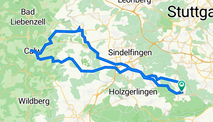
Waldenbuch/ Calw/ Weil der Stadt/ Sifi/ Waldenbuch
A cycling route starting in Waldenbuch, Baden-Württemberg, Germany.
Overview
About this route
- 5 h 39 min
- Duration
- 83.2 km
- Distance
- 956 m
- Ascent
- 954 m
- Descent
- 14.7 km/h
- Avg. speed
- 544 m
- Avg. speed
Route quality
Waytypes & surfaces along the route
Waytypes
Quiet road
21.7 km
(26 %)
Path
18.1 km
(22 %)
Surfaces
Paved
78.2 km
(94 %)
Unpaved
0.2 km
(<1 %)
Asphalt
75.4 km
(91 %)
Paving stones
1.4 km
(2 %)
Continue with Bikemap
Use, edit, or download this cycling route
You would like to ride Waldenbuch/ Calw/ Weil der Stadt/ Sifi/ Waldenbuch or customize it for your own trip? Here is what you can do with this Bikemap route:
Free features
- Save this route as favorite or in collections
- Copy & plan your own version of this route
- Split it into stages to create a multi-day tour
- Sync your route with Garmin or Wahoo
Premium features
Free trial for 3 days, or one-time payment. More about Bikemap Premium.
- Navigate this route on iOS & Android
- Export a GPX / KML file of this route
- Create your custom printout (try it for free)
- Download this route for offline navigation
Discover more Premium features.
Get Bikemap PremiumFrom our community
Other popular routes starting in Waldenbuch
 Waldenbuch über panzerkaserne über musberg nach waldenbuch
- Distance
- 25.3 km
- Ascent
- 310 m
- Descent
- 310 m
- Location
- Waldenbuch, Baden-Württemberg, Germany
 light jogging route
- Distance
- 6 km
- Ascent
- 155 m
- Descent
- 156 m
- Location
- Waldenbuch, Baden-Württemberg, Germany
 Morgentliche Tour zur Arbeit
- Distance
- 10.5 km
- Ascent
- 200 m
- Descent
- 86 m
- Location
- Waldenbuch, Baden-Württemberg, Germany
 Aichtal - Nürtingen - Neckartal
- Distance
- 65.9 km
- Ascent
- 251 m
- Descent
- 253 m
- Location
- Waldenbuch, Baden-Württemberg, Germany
 13km Laufstrecke / Biking Training Track Waldenbuch
- Distance
- 12.6 km
- Ascent
- 198 m
- Descent
- 200 m
- Location
- Waldenbuch, Baden-Württemberg, Germany
 Glashütte - Kochemmühle und zurück (8 km)
- Distance
- 8 km
- Ascent
- 184 m
- Descent
- 187 m
- Location
- Waldenbuch, Baden-Württemberg, Germany
 Stuttgart - Waldenbuch
- Distance
- 20.6 km
- Ascent
- 263 m
- Descent
- 315 m
- Location
- Waldenbuch, Baden-Württemberg, Germany
 Glashütte - Kochemmühle - Uhlberturm - Runde
- Distance
- 16.3 km
- Ascent
- 350 m
- Descent
- 350 m
- Location
- Waldenbuch, Baden-Württemberg, Germany
Open it in the app