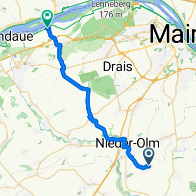
Weinbergstraße 16, Nieder-Olm nach Weinbergstraße 34, Nieder-Olm
A cycling route starting in Zornheim, Rhineland-Palatinate, Germany.
Overview
About this route
- 1 h
- Duration
- 15.4 km
- Distance
- 156 m
- Ascent
- 157 m
- Descent
- 15.3 km/h
- Avg. speed
- 244 m
- Avg. speed
Route quality
Waytypes & surfaces along the route
Waytypes
Track
11 km
(72 %)
Road
1.4 km
(9 %)
Surfaces
Paved
14 km
(91 %)
Unpaved
0 km
(<1 %)
Asphalt
6.6 km
(43 %)
Paved (undefined)
4.3 km
(28 %)
Continue with Bikemap
Use, edit, or download this cycling route
You would like to ride Weinbergstraße 16, Nieder-Olm nach Weinbergstraße 34, Nieder-Olm or customize it for your own trip? Here is what you can do with this Bikemap route:
Free features
- Save this route as favorite or in collections
- Copy & plan your own version of this route
- Sync your route with Garmin or Wahoo
Premium features
Free trial for 3 days, or one-time payment. More about Bikemap Premium.
- Navigate this route on iOS & Android
- Export a GPX / KML file of this route
- Create your custom printout (try it for free)
- Download this route for offline navigation
Discover more Premium features.
Get Bikemap PremiumFrom our community
Other popular routes starting in Zornheim
- Arbeit
- Distance
- 2.7 km
- Ascent
- 0 m
- Descent
- 92 m
- Location
- Zornheim, Rhineland-Palatinate, Germany
- Weinbergstraße 16, Nieder-Olm nach Weinbergstraße 34, Nieder-Olm
- Distance
- 15.4 km
- Ascent
- 156 m
- Descent
- 157 m
- Location
- Zornheim, Rhineland-Palatinate, Germany
- Rheinhessen Acht
- Distance
- 36.3 km
- Ascent
- 443 m
- Descent
- 447 m
- Location
- Zornheim, Rhineland-Palatinate, Germany
- Hiwweltour Zornheimer Berg
- Distance
- 6.8 km
- Ascent
- 191 m
- Descent
- 191 m
- Location
- Zornheim, Rhineland-Palatinate, Germany
- Zur Ebernburg
- Distance
- 35.5 km
- Ascent
- 278 m
- Descent
- 381 m
- Location
- Zornheim, Rhineland-Palatinate, Germany
- Moosbacher Mühle
- Distance
- 65.5 km
- Ascent
- 499 m
- Descent
- 499 m
- Location
- Zornheim, Rhineland-Palatinate, Germany
- 20160821_115926.gpx
- Distance
- 19.8 km
- Ascent
- 74 m
- Descent
- 190 m
- Location
- Zornheim, Rhineland-Palatinate, Germany
- Ingo Umweg
- Distance
- 17.1 km
- Ascent
- 227 m
- Descent
- 177 m
- Location
- Zornheim, Rhineland-Palatinate, Germany
Open it in the app