

322 Route du Mont Piron, Oudon à La Varenne, Orée d'Anjou
A cycling route starting in Champtoceaux, Pays de la Loire Region, France.
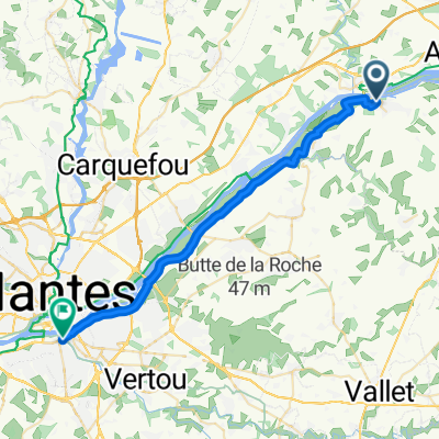
Overview
About this route
- 28 min
- Duration
- 8 km
- Distance
- 50 m
- Ascent
- 57 m
- Descent
- 17.2 km/h
- Avg. speed
- 32 m
- Max. altitude

Route quality
Waytypes & surfaces along the route
Waytypes
Quiet road
4.4 km
(55 %)
Cycleway
1.7 km
(21 %)
Surfaces
Paved
5.8 km
(72 %)
Unpaved
1.8 km
(23 %)
Asphalt
5.8 km
(72 %)
Gravel
1.8 km
(23 %)
Undefined
0.4 km
(5 %)
Continue with Bikemap
Use, edit, or download this cycling route
You would like to ride 322 Route du Mont Piron, Oudon à La Varenne, Orée d'Anjou or customize it for your own trip? Here is what you can do with this Bikemap route:
Free features
- Save this route as favorite or in collections
- Copy & plan your own version of this route
- Sync your route with Garmin or Wahoo
Premium features
Free trial for 3 days, or one-time payment. More about Bikemap Premium.
- Navigate this route on iOS & Android
- Export a GPX / KML file of this route
- Create your custom printout (try it for free)
- Download this route for offline navigation
Discover more Premium features.
Get Bikemap PremiumFrom our community
Other popular routes starting in Champtoceaux
 13 La Rivière 16, Orée-d'Anjou nach Chemin du Bout du Monde 1, Mauves-sur-Loire
- Distance
- 15.1 km
- Ascent
- 25 m
- Descent
- 29 m
- Location
- Champtoceaux, Pays de la Loire Region, France
 étape 3 - Loire 2025 - De Place du Chanoine Bricard à Avenue Anne Cazeneuve
- Distance
- 30.7 km
- Ascent
- 66 m
- Descent
- 130 m
- Location
- Champtoceaux, Pays de la Loire Region, France
 test
test- Distance
- 15.4 km
- Ascent
- 65 m
- Descent
- 43 m
- Location
- Champtoceaux, Pays de la Loire Region, France
 Recovered Route
- Distance
- 32.5 km
- Ascent
- 54 m
- Descent
- 59 m
- Location
- Champtoceaux, Pays de la Loire Region, France
 Etape 3: Champtoceaux - Montjean-sur-Loire
- Distance
- 42.1 km
- Ascent
- 145 m
- Descent
- 204 m
- Location
- Champtoceaux, Pays de la Loire Region, France
 Champtoceaux / Mauves-sur-Loire
- Distance
- 12.2 km
- Ascent
- 11 m
- Descent
- 27 m
- Location
- Champtoceaux, Pays de la Loire Region, France
 De 9 Rue Hippolyte Maindron, Champtoceaux à 40 Rue de Strasbourg, Nantes
- Distance
- 29.6 km
- Ascent
- 119 m
- Descent
- 174 m
- Location
- Champtoceaux, Pays de la Loire Region, France
 Champtoceaux-Test
- Distance
- 4.3 km
- Ascent
- 31 m
- Descent
- 31 m
- Location
- Champtoceaux, Pays de la Loire Region, France
Open it in the app