

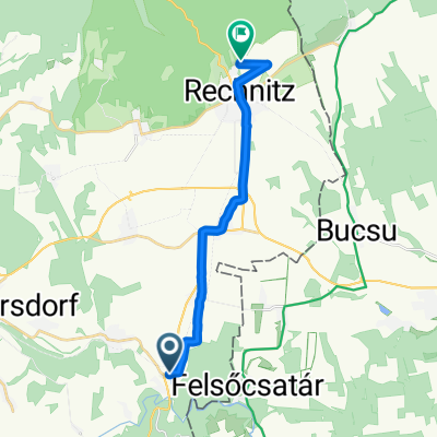
Bahntrassen-Radweg
A cycling route starting in Hannersdorf, Burgenland, Austria.
Overview
About this route
- -:--
- Duration
- 41.2 km
- Distance
- 420 m
- Ascent
- 340 m
- Descent
- ---
- Avg. speed
- 408 m
- Max. altitude

Route quality
Waytypes & surfaces along the route
Waytypes
Quiet road
8.2 km
(20 %)
Cycleway
7.4 km
(18 %)
Surfaces
Paved
26.3 km
(64 %)
Asphalt
26.3 km
(64 %)
Undefined
14.8 km
(36 %)
Continue with Bikemap
Use, edit, or download this cycling route
You would like to ride Bahntrassen-Radweg or customize it for your own trip? Here is what you can do with this Bikemap route:
Free features
- Save this route as favorite or in collections
- Copy & plan your own version of this route
- Sync your route with Garmin or Wahoo
Premium features
Free trial for 3 days, or one-time payment. More about Bikemap Premium.
- Navigate this route on iOS & Android
- Export a GPX / KML file of this route
- Create your custom printout (try it for free)
- Download this route for offline navigation
Discover more Premium features.
Get Bikemap PremiumFrom our community
Other popular routes starting in Hannersdorf
 Welgersdorf 80 nach Welgersdorf 80
- Distance
- 50.2 km
- Ascent
- 790 m
- Descent
- 786 m
- Location
- Hannersdorf, Burgenland, Austria
 Tour: SK-HR 2012 2: Burg - Čakovec
- Distance
- 122.4 km
- Ascent
- 330 m
- Descent
- 410 m
- Location
- Hannersdorf, Burgenland, Austria
 Burgenland 05
- Distance
- 34.8 km
- Ascent
- 435 m
- Descent
- 288 m
- Location
- Hannersdorf, Burgenland, Austria
 Burg Hannersdorf - Bad Gleischenberg
- Distance
- 78.4 km
- Ascent
- 479 m
- Descent
- 435 m
- Location
- Hannersdorf, Burgenland, Austria
 Hannersdorf 171 nach Hannersdorf 171
- Distance
- 62.7 km
- Ascent
- 850 m
- Descent
- 848 m
- Location
- Hannersdorf, Burgenland, Austria
 Radrunde von Hannersdorf nach Rechnitz
- Distance
- 14.4 km
- Ascent
- 225 m
- Descent
- 56 m
- Location
- Hannersdorf, Burgenland, Austria
 Burgi-tó Lövő
- Distance
- 55.5 km
- Ascent
- 271 m
- Descent
- 328 m
- Location
- Hannersdorf, Burgenland, Austria
 Hochcsater-retour
- Distance
- 34.3 km
- Ascent
- 457 m
- Descent
- 462 m
- Location
- Hannersdorf, Burgenland, Austria
Open it in the app