

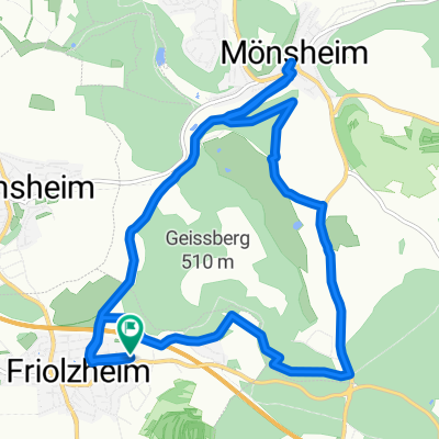
Würmtal Cross
A cycling route starting in Friolzheim, Baden-Wurttemberg, Germany.
Overview
About this route
leichte Cyclocrosstour von Friolzheim ins Würmtal über Burg Liebeneck nach Würm. Den Würmtalradweg bis nach Steinegg, dann über Mühlhausen zurück. 330Hm 1:30h 29km Straßen, befestugte Wege, Schotter. Zwei nennenswerte Anstiege ca. 10-15%
- -:--
- Duration
- 28.9 km
- Distance
- 592 m
- Ascent
- 623 m
- Descent
- ---
- Avg. speed
- 479 m
- Max. altitude

Route quality
Waytypes & surfaces along the route
Waytypes
Track
24 km
(83 %)
Busy road
1.9 km
(6 %)
Surfaces
Paved
9.5 km
(33 %)
Unpaved
19.3 km
(67 %)
Gravel
12.3 km
(42 %)
Asphalt
7.7 km
(27 %)
Continue with Bikemap
Use, edit, or download this cycling route
You would like to ride Würmtal Cross or customize it for your own trip? Here is what you can do with this Bikemap route:
Free features
- Save this route as favorite or in collections
- Copy & plan your own version of this route
- Sync your route with Garmin or Wahoo
Premium features
Free trial for 3 days, or one-time payment. More about Bikemap Premium.
- Navigate this route on iOS & Android
- Export a GPX / KML file of this route
- Create your custom printout (try it for free)
- Download this route for offline navigation
Discover more Premium features.
Get Bikemap PremiumFrom our community
Other popular routes starting in Friolzheim
 "Winter-Würmtal-Cross"
- Distance
- 25.2 km
- Ascent
- 336 m
- Descent
- 338 m
- Location
- Friolzheim, Baden-Wurttemberg, Germany
 Friolzheim / Römerhügel / Seehausstr. / Tiefenbronn / Friolzheim
- Distance
- 11.2 km
- Ascent
- 119 m
- Descent
- 119 m
- Location
- Friolzheim, Baden-Wurttemberg, Germany
 NSW Bad Wildbad-Meisternberg-Bad Teinach
- Distance
- 104.3 km
- Ascent
- 1,833 m
- Descent
- 1,845 m
- Location
- Friolzheim, Baden-Wurttemberg, Germany
 Friolzheim - Schwarzwaldhochstraße
- Distance
- 197.8 km
- Ascent
- 2,170 m
- Descent
- 2,171 m
- Location
- Friolzheim, Baden-Wurttemberg, Germany
 Friolzheim / Freizeitpark Rutesheim
- Distance
- 17.7 km
- Ascent
- 298 m
- Descent
- 298 m
- Location
- Friolzheim, Baden-Wurttemberg, Germany
 Friolzheim / Mönsheim (Golf Club) CLONED FROM ROUTE 1744575
- Distance
- 12.8 km
- Ascent
- 293 m
- Descent
- 293 m
- Location
- Friolzheim, Baden-Wurttemberg, Germany
 friolzheim richtung seehaus
- Distance
- 10 km
- Ascent
- 131 m
- Descent
- 162 m
- Location
- Friolzheim, Baden-Wurttemberg, Germany
 friolzheim zum minigolf rutesheim
- Distance
- 18.4 km
- Ascent
- 288 m
- Descent
- 290 m
- Location
- Friolzheim, Baden-Wurttemberg, Germany
Open it in the app