

1991 10etapa
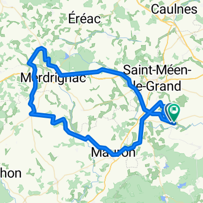
A cycling route starting in Gaël, Brittany Region, France.
Overview
About this route
0
- -:--
- Duration
- 126.7 km
- Distance
- 654 m
- Ascent
- 579 m
- Descent
- ---
- Avg. speed
- ---
- Max. altitude
Route quality
Waytypes & surfaces along the route
Waytypes
Road
31.7 km
25 %
Quiet road
24.1 km
19 %
Surfaces
Paved
21.5 km
(17 %)
Unpaved
2.5 km
(2 %)
Asphalt
21.5 km
17 %
Gravel
1.3 km
1 %
Continue with Bikemap
Use, edit, or download this cycling route
You would like to ride 1991 10etapa or customize it for your own trip? Here is what you can do with this Bikemap route:
Free features
- Save this route as favorite or in collections
- Copy & plan your own version of this route
- Split it into stages to create a multi-day tour
- Sync your route with Garmin or Wahoo
Premium features
Free trial for 3 days, or one-time payment. More about Bikemap Premium.
- Navigate this route on iOS & Android
- Export a GPX / KML file of this route
- Create your custom printout (try it for free)
- Download this route for offline navigation
Discover more Premium features.
Get Bikemap PremiumFrom our community
Other popular routes starting in Gaël
- 10 Le Tertre, Loscouët-sur-Meu to 1 Esplanade de Brocéliande, Paimpont0
- 19.7 km
- 249 m
- 189 m
- Gaël, Brittany Region, France


Open it in the app