

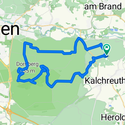
NU__Forchheim__Obertrubach_Graefenberg__NU
A cycling route starting in Kalchreuth, Bavaria, Germany.
Overview
About this route
- -:--
- Duration
- 99.1 km
- Distance
- 527 m
- Ascent
- 554 m
- Descent
- ---
- Avg. speed
- ---
- Max. altitude
Route quality
Waytypes & surfaces along the route
Waytypes
Track
37.6 km
(38 %)
Quiet road
25.8 km
(26 %)
Surfaces
Paved
47.6 km
(48 %)
Unpaved
28.7 km
(29 %)
Asphalt
42.6 km
(43 %)
Gravel
19.8 km
(20 %)
Continue with Bikemap
Use, edit, or download this cycling route
You would like to ride NU__Forchheim__Obertrubach_Graefenberg__NU or customize it for your own trip? Here is what you can do with this Bikemap route:
Free features
- Save this route as favorite or in collections
- Copy & plan your own version of this route
- Split it into stages to create a multi-day tour
- Sync your route with Garmin or Wahoo
Premium features
Free trial for 3 days, or one-time payment. More about Bikemap Premium.
- Navigate this route on iOS & Android
- Export a GPX / KML file of this route
- Create your custom printout (try it for free)
- Download this route for offline navigation
Discover more Premium features.
Get Bikemap PremiumFrom our community
Other popular routes starting in Kalchreuth
 D_Bayern_Nürnberg-Singletrail02_Kalchreuth-Kahlberg
- Distance
- 0.9 km
- Ascent
- 8 m
- Descent
- 47 m
- Location
- Kalchreuth, Bavaria, Germany
 Reichswaldtour (ca. 35km)
- Distance
- 34.9 km
- Ascent
- 209 m
- Descent
- 209 m
- Location
- Kalchreuth, Bavaria, Germany
 D_Bayern_Nürnberg-Singletrail03_Kalchreuth-Teufelstisch
- Distance
- 1 km
- Ascent
- 0 m
- Descent
- 42 m
- Location
- Kalchreuth, Bavaria, Germany
 Jakobsweg Kalchreuth-Heidenheim
- Distance
- 101.4 km
- Ascent
- 596 m
- Descent
- 478 m
- Location
- Kalchreuth, Bavaria, Germany
 Rund um Kalchreuth
- Distance
- 44.6 km
- Ascent
- 417 m
- Descent
- 529 m
- Location
- Kalchreuth, Bavaria, Germany
 Klettertouren Rund um Kirchsittenbach
- Distance
- 117 km
- Ascent
- 1,172 m
- Descent
- 1,172 m
- Location
- Kalchreuth, Bavaria, Germany
 Ausflugsrunde 2013-10-03 (ca. 26km)
- Distance
- 25.6 km
- Ascent
- 168 m
- Descent
- 169 m
- Location
- Kalchreuth, Bavaria, Germany
 Schnelle Tour in kalchreuth
- Distance
- 14.2 km
- Ascent
- 43 m
- Descent
- 141 m
- Location
- Kalchreuth, Bavaria, Germany
Open it in the app