

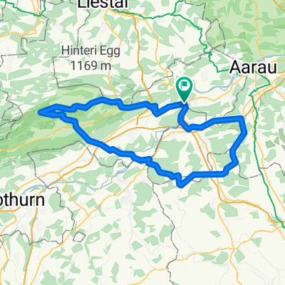
Schafmattrunde Olten
A cycling route starting in Olten, Canton of Solothurn, Switzerland.
Overview
About this route
nice hilly route through the Jura starting from Olten with the Schafmatt Pass
- -:--
- Duration
- 37.3 km
- Distance
- 909 m
- Ascent
- 890 m
- Descent
- ---
- Avg. speed
- 818 m
- Max. altitude

Route quality
Waytypes & surfaces along the route
Waytypes
Road
13.4 km
(36 %)
Quiet road
7.1 km
(19 %)
Surfaces
Paved
29.1 km
(78 %)
Unpaved
1.1 km
(3 %)
Asphalt
26.9 km
(72 %)
Paved (undefined)
2.2 km
(6 %)
Continue with Bikemap
Use, edit, or download this cycling route
You would like to ride Schafmattrunde Olten or customize it for your own trip? Here is what you can do with this Bikemap route:
Free features
- Save this route as favorite or in collections
- Copy & plan your own version of this route
- Sync your route with Garmin or Wahoo
Premium features
Free trial for 3 days, or one-time payment. More about Bikemap Premium.
- Navigate this route on iOS & Android
- Export a GPX / KML file of this route
- Create your custom printout (try it for free)
- Download this route for offline navigation
Discover more Premium features.
Get Bikemap PremiumFrom our community
Other popular routes starting in Olten
 Olten - Hauenstein - Schaafmatt - Olten
- Distance
- 31.5 km
- Ascent
- 652 m
- Descent
- 655 m
- Location
- Olten, Canton of Solothurn, Switzerland
 Valentino-Löwen Rennen. Olten-Gränichen-Olten
- Distance
- 44.2 km
- Ascent
- 416 m
- Descent
- 406 m
- Location
- Olten, Canton of Solothurn, Switzerland
 Glaubenberg, Glaubenbüehlen, Lüderealp
- Distance
- 208.4 km
- Ascent
- 2,690 m
- Descent
- 2,703 m
- Location
- Olten, Canton of Solothurn, Switzerland
 20151113 AG/BL/SO-Combo
- Distance
- 60.1 km
- Ascent
- 1,419 m
- Descent
- 1,419 m
- Location
- Olten, Canton of Solothurn, Switzerland
 Schützenmattweg 12, Olten nach Forstackerstrasse 4F, Zofingen
- Distance
- 10 km
- Ascent
- 84 m
- Descent
- 38 m
- Location
- Olten, Canton of Solothurn, Switzerland
 Olten - Mümliswil - Brunnersberg - Kestenholz
- Distance
- 93.5 km
- Ascent
- 1,455 m
- Descent
- 1,454 m
- Location
- Olten, Canton of Solothurn, Switzerland
 Oltiger stich
- Distance
- 42.6 km
- Ascent
- 884 m
- Descent
- 884 m
- Location
- Olten, Canton of Solothurn, Switzerland
 Olten - Moutier
- Distance
- 58.8 km
- Ascent
- 2,201 m
- Descent
- 1,802 m
- Location
- Olten, Canton of Solothurn, Switzerland
Open it in the app