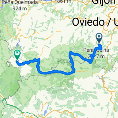
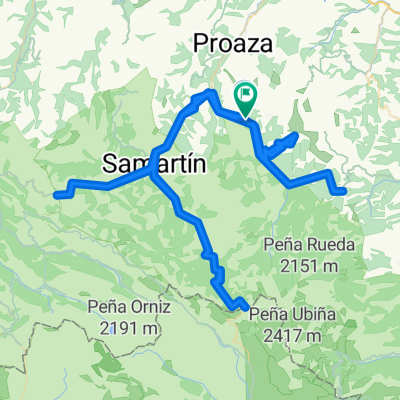
Gamoniteiru por Lindes y Cortes
A cycling route starting in Bárzana, Principality of Asturias, Spain.
Overview
About this route
Falta trozo de carretera de 1km aproximadamente en la subida a la Cobertoria por Lindes
- -:--
- Duration
- 75.9 km
- Distance
- 1,673 m
- Ascent
- 1,768 m
- Descent
- ---
- Avg. speed
- ---
- Avg. speed
Route quality
Waytypes & surfaces along the route
Waytypes
Busy road
40.6 km
(53 %)
Quiet road
18.8 km
(25 %)
Surfaces
Paved
66.6 km
(88 %)
Asphalt
65.5 km
(86 %)
Paved (undefined)
0.8 km
(1 %)
Continue with Bikemap
Use, edit, or download this cycling route
You would like to ride Gamoniteiru por Lindes y Cortes or customize it for your own trip? Here is what you can do with this Bikemap route:
Free features
- Save this route as favorite or in collections
- Copy & plan your own version of this route
- Sync your route with Garmin or Wahoo
Premium features
Free trial for 3 days, or one-time payment. More about Bikemap Premium.
- Navigate this route on iOS & Android
- Export a GPX / KML file of this route
- Create your custom printout (try it for free)
- Download this route for offline navigation
Discover more Premium features.
Get Bikemap PremiumFrom our community
Other popular routes starting in Bárzana
- Bárzana, Cobertoria por las Llanas, Gamoniteiro, Bárzana, Ermita de Alba, Bárzana.
- Distance
- 64.9 km
- Ascent
- 2,099 m
- Descent
- 2,102 m
- Location
- Bárzana, Principality of Asturias, Spain
- Ponferrada - Alto de Gamoniteiro
- Distance
- 186.3 km
- Ascent
- 3,005 m
- Descent
- 4,280 m
- Location
- Bárzana, Principality of Asturias, Spain
- ERMITA del ALBA, por Bárzana
- Distance
- 6.9 km
- Ascent
- 819 m
- Descent
- 59 m
- Location
- Bárzana, Principality of Asturias, Spain
- TROBANIELLO, por Quirós
- Distance
- 16.9 km
- Ascent
- 1,178 m
- Descent
- 77 m
- Location
- Bárzana, Principality of Asturias, Spain
- Kalendarz The Climb 2020
- Distance
- 5,441.3 km
- Ascent
- 8,794 m
- Descent
- 10,345 m
- Location
- Bárzana, Principality of Asturias, Spain
- Senda del Oso completa, Santa Marina - Tuñón - Entrago
- Distance
- 44 km
- Ascent
- 1,232 m
- Descent
- 1,271 m
- Location
- Bárzana, Principality of Asturias, Spain
- RUTA CARRETERA POR VALLE QUIROS
- Distance
- 33.7 km
- Ascent
- 1,974 m
- Descent
- 1,981 m
- Location
- Bárzana, Principality of Asturias, Spain
- Bárzana, Cobertoria (por Lindes), Gamoniteiro, Ermita de Alba, Bárzana
- Distance
- 64.7 km
- Ascent
- 2,067 m
- Descent
- 2,071 m
- Location
- Bárzana, Principality of Asturias, Spain