
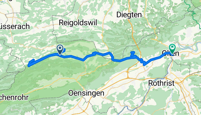
Scheltenpass-Passwang-Allerheiligen-Olten
A cycling route starting in Laupersdorf, Canton of Solothurn, Switzerland.
Overview
About this route
Pässetour im Jura
- -:--
- Duration
- 51.4 km
- Distance
- 1,216 m
- Ascent
- 1,495 m
- Descent
- ---
- Avg. speed
- ---
- Max. altitude

Continue with Bikemap
Use, edit, or download this cycling route
You would like to ride Scheltenpass-Passwang-Allerheiligen-Olten or customize it for your own trip? Here is what you can do with this Bikemap route:
Free features
- Save this route as favorite or in collections
- Copy & plan your own version of this route
- Sync your route with Garmin or Wahoo
Premium features
Free trial for 3 days, or one-time payment. More about Bikemap Premium.
- Navigate this route on iOS & Android
- Export a GPX / KML file of this route
- Create your custom printout (try it for free)
- Download this route for offline navigation
Discover more Premium features.
Get Bikemap PremiumFrom our community
Other popular routes starting in Laupersdorf
 Scheltenpass-Passwang-Allerheiligen-Olten
- Distance
- 51.4 km
- Ascent
- 1,216 m
- Descent
- 1,495 m
- Location
- Laupersdorf, Canton of Solothurn, Switzerland
 Brunnersberg-Brocheten-Katertürli
- Distance
- 26.7 km
- Ascent
- 636 m
- Descent
- 650 m
- Location
- Laupersdorf, Canton of Solothurn, Switzerland
 Thal-Aareufer-Balmberg-Schnapswägli-Tour
- Distance
- 59.5 km
- Ascent
- 858 m
- Descent
- 858 m
- Location
- Laupersdorf, Canton of Solothurn, Switzerland
 Brunnersberg, Welschenrohr, Laupersdorf
- Distance
- 27.8 km
- Ascent
- 739 m
- Descent
- 740 m
- Location
- Laupersdorf, Canton of Solothurn, Switzerland
 Brunnersberg-Lätt Türli
- Distance
- 18.6 km
- Ascent
- 582 m
- Descent
- 583 m
- Location
- Laupersdorf, Canton of Solothurn, Switzerland
 Laupersdorf-Bärenwil-Oensingen-Laupersdorf
- Distance
- 34.1 km
- Ascent
- 744 m
- Descent
- 744 m
- Location
- Laupersdorf, Canton of Solothurn, Switzerland
 Oberberg-Bremgarten-Schanzenwägli-Tour
- Distance
- 19 km
- Ascent
- 532 m
- Descent
- 529 m
- Location
- Laupersdorf, Canton of Solothurn, Switzerland
 Passwang-Mariastein
- Distance
- 35.1 km
- Ascent
- 1,178 m
- Descent
- 1,496 m
- Location
- Laupersdorf, Canton of Solothurn, Switzerland
Open it in the app