
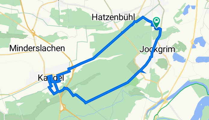
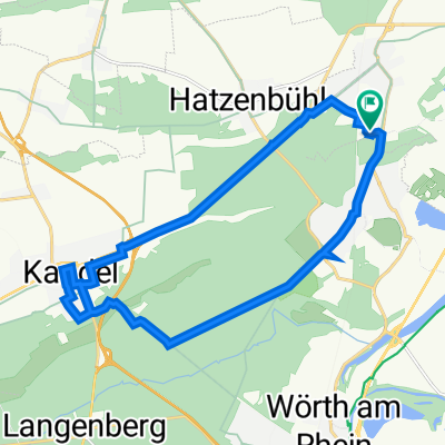
An den Tongruben 24A, Rheinzabern nach An den Tongruben 24A, Rheinzabern
A cycling route starting in Jockgrim, Rhineland-Palatinate, Germany.
Overview
About this route
- 1 h 12 min
- Duration
- 19.3 km
- Distance
- 61 m
- Ascent
- 59 m
- Descent
- 16.1 km/h
- Avg. speed
- 132 m
- Max. altitude

Route quality
Waytypes & surfaces along the route
Waytypes
Track
6.4 km
(33 %)
Path
5.6 km
(29 %)
Surfaces
Paved
14.7 km
(76 %)
Unpaved
3.3 km
(17 %)
Asphalt
13.7 km
(71 %)
Loose gravel
2.5 km
(13 %)
Continue with Bikemap
Use, edit, or download this cycling route
You would like to ride An den Tongruben 24A, Rheinzabern nach An den Tongruben 24A, Rheinzabern or customize it for your own trip? Here is what you can do with this Bikemap route:
Free features
- Save this route as favorite or in collections
- Copy & plan your own version of this route
- Sync your route with Garmin or Wahoo
Premium features
Free trial for 3 days, or one-time payment. More about Bikemap Premium.
- Navigate this route on iOS & Android
- Export a GPX / KML file of this route
- Create your custom printout (try it for free)
- Download this route for offline navigation
Discover more Premium features.
Get Bikemap PremiumFrom our community
Other popular routes starting in Jockgrim
 Jockgrim - Dahn
- Distance
- 56.8 km
- Ascent
- 311 m
- Descent
- 203 m
- Location
- Jockgrim, Rhineland-Palatinate, Germany
 Hausbräu/Göcklingen
- Distance
- 22.2 km
- Ascent
- 119 m
- Descent
- 57 m
- Location
- Jockgrim, Rhineland-Palatinate, Germany
 Jockgrim - Dahn
- Distance
- 56.8 km
- Ascent
- 356 m
- Descent
- 245 m
- Location
- Jockgrim, Rhineland-Palatinate, Germany
 Bienwald-Umrundung
- Distance
- 80.4 km
- Ascent
- 126 m
- Descent
- 126 m
- Location
- Jockgrim, Rhineland-Palatinate, Germany
 Eurovelo Route 15
- Distance
- 1,890.3 km
- Ascent
- 1,728 m
- Descent
- 1,838 m
- Location
- Jockgrim, Rhineland-Palatinate, Germany
 An den Tongruben 24A, Rheinzabern nach An den Tongruben 24A, Rheinzabern
- Distance
- 19.3 km
- Ascent
- 61 m
- Descent
- 59 m
- Location
- Jockgrim, Rhineland-Palatinate, Germany
 Südpfalz - Rheinschleife für Genießer
- Distance
- 39.1 km
- Ascent
- 36 m
- Descent
- 36 m
- Location
- Jockgrim, Rhineland-Palatinate, Germany
 Dusseldorf - Lyon
- Distance
- 1,407.8 km
- Ascent
- 0 m
- Descent
- 0 m
- Location
- Jockgrim, Rhineland-Palatinate, Germany
Open it in the app