

Ride Day 22—3 Oct 2005—34220 St-Pons-de-Thomières to 81320 Murat-sur-Vèbre
A cycling route starting in Saint-Pons-de-Thomières, Occitanie, France.
Overview
About this route
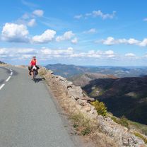
<span style="font-size: 12pt; font-family: Arial;">Today’s area and roads were outstanding.<span> </span>Only D907 had more traffic than we would have liked.<span> </span>Also, we passed from the Hérault Department into the Tarn Department.<span> </span>This also meant that we’d left the Languedoc-Roussillon Region and entered the Midi-Pyrénées Region.</span>
<span style="font-size: 12pt; font-family: Arial;">Starting from St Pons at 320 M, we immediately climbed to 941 M at the first col and from then until arriving in Murat, we descended and climbed within a 200 or so meter band until finishing at 840 M in Murat.</span>
<span style="font-size: 12pt; font-family: Arial;">Just before reaching the first col, we stopped and were just about frozen by the gale force cold wind.<span> </span>After putting on our rain pants, jerseys and gloves, we felt much better.<span> </span>Happily, we had no rain until the last four miles or so along D162Cand D162 into Murat.</span>
Background:<br /><br /><br />My wife and I have been doing self-supported tours in Western Europe (a majority in France) since 1993. This series of rides covers our 2005 2 month route through parts of France. Our beginning and ending point is near Chaduri (south of Angoulême) where our friends have a farm with Gites and Chambres d'Hotes.<br /><br /><br />We rode our Dawes touring bicycles purchased in 1993 heavily loaded with 700Cx32 tires. All of our riding was on paved roads, mostly with very little traffic.<br /><br /><br />If any questions, feel free to email me at jeffkadet@netdiving.com<br /><br /><br />Jeff
- -:--
- Duration
- 40.5 km
- Distance
- 1,041 m
- Ascent
- 511 m
- Descent
- ---
- Avg. speed
- ---
- Max. altitude

Route quality
Waytypes & surfaces along the route
Waytypes
Road
20.1 km
(50 %)
Busy road
18.6 km
(46 %)
Surfaces
Paved
1 km
(2 %)
Asphalt
1 km
(2 %)
Undefined
39.5 km
(98 %)
Continue with Bikemap
Use, edit, or download this cycling route
You would like to ride Ride Day 22—3 Oct 2005—34220 St-Pons-de-Thomières to 81320 Murat-sur-Vèbre or customize it for your own trip? Here is what you can do with this Bikemap route:
Free features
- Save this route as favorite or in collections
- Copy & plan your own version of this route
- Sync your route with Garmin or Wahoo
Premium features
Free trial for 3 days, or one-time payment. More about Bikemap Premium.
- Navigate this route on iOS & Android
- Export a GPX / KML file of this route
- Create your custom printout (try it for free)
- Download this route for offline navigation
Discover more Premium features.
Get Bikemap PremiumFrom our community
Other popular routes starting in Saint-Pons-de-Thomières
 2015_FR_110 km_1950hm
- Distance
- 108.9 km
- Ascent
- 1,522 m
- Descent
- 1,601 m
- Location
- Saint-Pons-de-Thomières, Occitanie, France
 Leg 2 Day 4 kurz
- Distance
- 113.1 km
- Ascent
- 869 m
- Descent
- 1,053 m
- Location
- Saint-Pons-de-Thomières, Occitanie, France
 2019 Mazamet-Herepian
- Distance
- 13.2 km
- Ascent
- 177 m
- Descent
- 63 m
- Location
- Saint-Pons-de-Thomières, Occitanie, France
 Etape 16 – De Lacan à Minerve - Itinéraire Sud
- Distance
- 17.8 km
- Ascent
- 397 m
- Descent
- 684 m
- Location
- Saint-Pons-de-Thomières, Occitanie, France
 BALADE AUTOUR DE ST P0NS
- Distance
- 79.1 km
- Ascent
- 1,158 m
- Descent
- 1,158 m
- Location
- Saint-Pons-de-Thomières, Occitanie, France
 Ride Day 22—3 Oct 2005—34220 St-Pons-de-Thomières to 81320 Murat-sur-Vèbre
- Distance
- 40.5 km
- Ascent
- 1,041 m
- Descent
- 511 m
- Location
- Saint-Pons-de-Thomières, Occitanie, France
 Saint-Pons-de-Thomières - Lamalou-les-Bains
- Distance
- 72.9 km
- Ascent
- 1,178 m
- Descent
- 1,284 m
- Location
- Saint-Pons-de-Thomières, Occitanie, France
 Etape 15 – De Rodomouls à Lacan - Itinéraire Sud
- Distance
- 16.9 km
- Ascent
- 402 m
- Descent
- 482 m
- Location
- Saint-Pons-de-Thomières, Occitanie, France
Open it in the app