

Mountainbiketour 005 mit 33Km und 950Hm
A cycling route starting in Bühlertal, Baden-Wurttemberg, Germany.
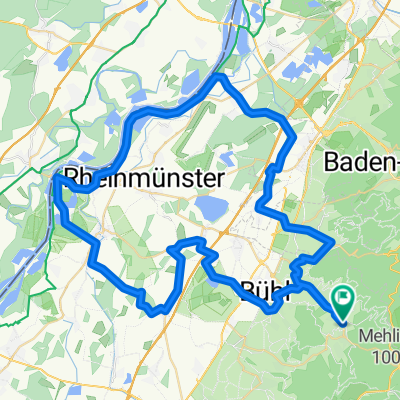
Overview
About this route
Wegpunkte:
Start in Bühlertal -> Malschbach -> Bütthof -> Grimbach Hütte -> Herrenwieser Sattel -> Plättig -> Philosophenweg -> Schwanenwasen -> Bildeiche -> Hexenbrunnen -> Winzerpavillion - Bühlertal
Wunderschöne Strecke mit vorwiegend Waldwegen und Trails.
Nichts für Ungeübte und nur für Mountainbikes geeignet.
Viel Spaß!
- -:--
- Duration
- 32.1 km
- Distance
- 868 m
- Ascent
- 868 m
- Descent
- ---
- Avg. speed
- ---
- Max. altitude
Continue with Bikemap
Use, edit, or download this cycling route
You would like to ride Mountainbiketour 005 mit 33Km und 950Hm or customize it for your own trip? Here is what you can do with this Bikemap route:
Free features
- Save this route as favorite or in collections
- Copy & plan your own version of this route
- Sync your route with Garmin or Wahoo
Premium features
Free trial for 3 days, or one-time payment. More about Bikemap Premium.
- Navigate this route on iOS & Android
- Export a GPX / KML file of this route
- Create your custom printout (try it for free)
- Download this route for offline navigation
Discover more Premium features.
Get Bikemap PremiumFrom our community
Other popular routes starting in Bühlertal
 Bühlertäler Gebirgstour / Falkenfels Bühlertal
- Distance
- 94.1 km
- Ascent
- 2,600 m
- Descent
- 2,307 m
- Location
- Bühlertal, Baden-Wurttemberg, Germany
 Bühlertal-Scherrhof-Bütthof-Bühlertal
- Distance
- 32 km
- Ascent
- 1,302 m
- Descent
- 1,314 m
- Location
- Bühlertal, Baden-Wurttemberg, Germany
 Permanente Nordschwarzwald Total
- Distance
- 96.4 km
- Ascent
- 2,301 m
- Descent
- 2,080 m
- Location
- Bühlertal, Baden-Wurttemberg, Germany
 Schwimmbad Bühlertal - Hornisgrinde Rundweg
- Distance
- 44.4 km
- Ascent
- 1,131 m
- Descent
- 1,128 m
- Location
- Bühlertal, Baden-Wurttemberg, Germany
 3 Stunden Strecke
- Distance
- 36.5 km
- Ascent
- 958 m
- Descent
- 958 m
- Location
- Bühlertal, Baden-Wurttemberg, Germany
 Von Bühlertal bis Bundenthal
- Distance
- 145.1 km
- Ascent
- 1,902 m
- Descent
- 2,204 m
- Location
- Bühlertal, Baden-Wurttemberg, Germany
 Mountainbiketour 005 mit 33Km und 950Hm
- Distance
- 32.1 km
- Ascent
- 868 m
- Descent
- 868 m
- Location
- Bühlertal, Baden-Wurttemberg, Germany
 Permanente Bühlertal-Rheintal Tour
- Distance
- 69.8 km
- Ascent
- 290 m
- Descent
- 404 m
- Location
- Bühlertal, Baden-Wurttemberg, Germany
Open it in the app