

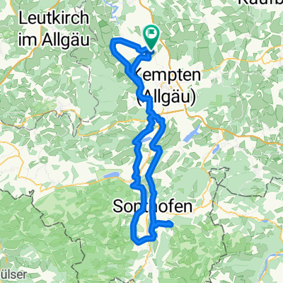
Hinteregg-Hängebrücke
A cycling route starting in Lauben, Bavaria, Germany.
Overview
About this route
- -:--
- Duration
- 29.7 km
- Distance
- 485 m
- Ascent
- 485 m
- Descent
- ---
- Avg. speed
- 831 m
- Max. altitude

Route quality
Waytypes & surfaces along the route
Waytypes
Quiet road
22.3 km
(75 %)
Road
2.4 km
(8 %)
Surfaces
Paved
17.2 km
(58 %)
Unpaved
1.8 km
(6 %)
Asphalt
16.6 km
(56 %)
Gravel
0.6 km
(2 %)
Continue with Bikemap
Use, edit, or download this cycling route
You would like to ride Hinteregg-Hängebrücke or customize it for your own trip? Here is what you can do with this Bikemap route:
Free features
- Save this route as favorite or in collections
- Copy & plan your own version of this route
- Sync your route with Garmin or Wahoo
Premium features
Free trial for 3 days, or one-time payment. More about Bikemap Premium.
- Navigate this route on iOS & Android
- Export a GPX / KML file of this route
- Create your custom printout (try it for free)
- Download this route for offline navigation
Discover more Premium features.
Get Bikemap PremiumFrom our community
Other popular routes starting in Lauben
 Wild West ride out - small version
- Distance
- 9.9 km
- Ascent
- 86 m
- Descent
- 86 m
- Location
- Lauben, Bavaria, Germany
 Krugzell - Sonthofener Hof
- Distance
- 124.6 km
- Ascent
- 1,003 m
- Descent
- 1,003 m
- Location
- Lauben, Bavaria, Germany
 Hochgratweg 24, Lauben nach Hochgratweg 20, Lauben
- Distance
- 48.7 km
- Ascent
- 1,820 m
- Descent
- 1,822 m
- Location
- Lauben, Bavaria, Germany
 Tagestour entlang der Allgäuer Alpen
- Distance
- 164.9 km
- Ascent
- 1,064 m
- Descent
- 1,060 m
- Location
- Lauben, Bavaria, Germany
 Winklerstraße 32, Lauben nach Winklerstraße 32, Lauben
- Distance
- 500.1 km
- Ascent
- 3,829 m
- Descent
- 3,859 m
- Location
- Lauben, Bavaria, Germany
 Daily Route
- Distance
- 33.1 km
- Ascent
- 397 m
- Descent
- 397 m
- Location
- Lauben, Bavaria, Germany
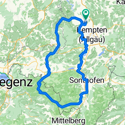
 Rund um Kempten
- Distance
- 107.4 km
- Ascent
- 894 m
- Descent
- 894 m
- Location
- Lauben, Bavaria, Germany
 Hinteregg-Hängebrücke
- Distance
- 29.7 km
- Ascent
- 485 m
- Descent
- 485 m
- Location
- Lauben, Bavaria, Germany
Open it in the app