
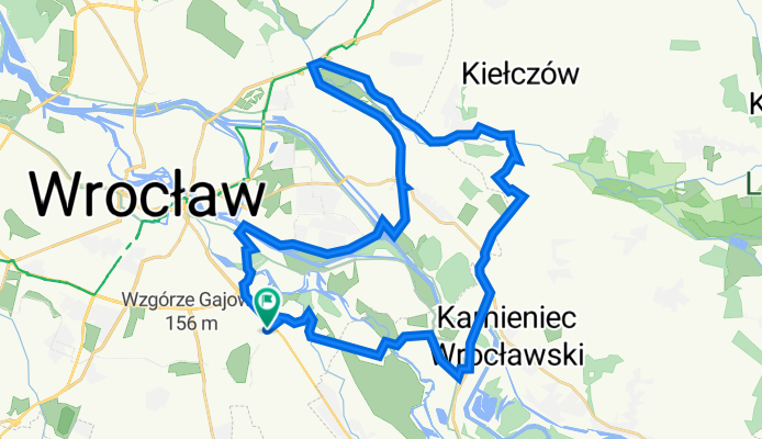
Głubczycka 6, Wrocław do Głubczycka 8B, Wrocław
A cycling route starting in Radwanice, Lower Silesian Voivodeship, Poland.
Overview
About this route
- 2 h 24 min
- Duration
- 38 km
- Distance
- 842 m
- Ascent
- 853 m
- Descent
- 15.8 km/h
- Avg. speed
- 168 m
- Max. altitude

Route quality
Waytypes & surfaces along the route
Waytypes
Path
13.7 km
(36 %)
Track
9.1 km
(24 %)
Surfaces
Paved
16.7 km
(44 %)
Unpaved
16.3 km
(43 %)
Asphalt
14.1 km
(37 %)
Gravel
14.1 km
(37 %)
Continue with Bikemap
Use, edit, or download this cycling route
You would like to ride Głubczycka 6, Wrocław do Głubczycka 8B, Wrocław or customize it for your own trip? Here is what you can do with this Bikemap route:
Free features
- Save this route as favorite or in collections
- Copy & plan your own version of this route
- Sync your route with Garmin or Wahoo
Premium features
Free trial for 3 days, or one-time payment. More about Bikemap Premium.
- Navigate this route on iOS & Android
- Export a GPX / KML file of this route
- Create your custom printout (try it for free)
- Download this route for offline navigation
Discover more Premium features.
Get Bikemap PremiumFrom our community
Other popular routes starting in Radwanice
 Głubczycka 6, Wrocław do Głubczycka 8B, Wrocław
- Distance
- 38 km
- Ascent
- 842 m
- Descent
- 853 m
- Location
- Radwanice, Lower Silesian Voivodeship, Poland
 Mokry Dwor-WOW (petla)
- Distance
- 11.1 km
- Ascent
- 4 m
- Descent
- 4 m
- Location
- Radwanice, Lower Silesian Voivodeship, Poland
 wyboista i malownicza trasa przez najpopularniejszy single track w Kotowicach
- Distance
- 54.3 km
- Ascent
- 161 m
- Descent
- 159 m
- Location
- Radwanice, Lower Silesian Voivodeship, Poland
 taki pomysl jest
- Distance
- 9.4 km
- Ascent
- 9 m
- Descent
- 8 m
- Location
- Radwanice, Lower Silesian Voivodeship, Poland
![[Wrocław 01] Księże - Gaj - Powstańców - Terenowa - Brochów - Radwanice - Wały - Odra](https://media.bikemap.net/routes/3032024/staticmaps/in_2db79db0-8d2c-4594-8737-88e8ad89c89e_400x400_bikemap-2021-3D-static.png) [Wrocław 01] Księże - Gaj - Powstańców - Terenowa - Brochów - Radwanice - Wały - Odra
[Wrocław 01] Księże - Gaj - Powstańców - Terenowa - Brochów - Radwanice - Wały - Odra- Distance
- 37.5 km
- Ascent
- 27 m
- Descent
- 28 m
- Location
- Radwanice, Lower Silesian Voivodeship, Poland
 Trasa widokowa - wschód
- Distance
- 17.2 km
- Ascent
- 24 m
- Descent
- 26 m
- Location
- Radwanice, Lower Silesian Voivodeship, Poland
 Kotowice - wieża widokowa
- Distance
- 58.2 km
- Ascent
- 49 m
- Descent
- 52 m
- Location
- Radwanice, Lower Silesian Voivodeship, Poland
 Twierdza Wrocław
- Distance
- 57.6 km
- Ascent
- 50 m
- Descent
- 53 m
- Location
- Radwanice, Lower Silesian Voivodeship, Poland
Open it in the app