

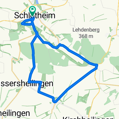
Steinweg 38, Nottertal-Heilinger Höhen nach Bergstraße 4, Nottertal-Heilinger Höhen
A cycling route starting in Schlotheim, Thuringia, Germany.
Overview
About this route
- 2 h 43 min
- Duration
- 38.5 km
- Distance
- 461 m
- Ascent
- 506 m
- Descent
- 14.2 km/h
- Avg. speed
- 356 m
- Max. altitude
Route photos

Route quality
Waytypes & surfaces along the route
Waytypes
Track
10.8 km
(28 %)
Road
6.9 km
(18 %)
Surfaces
Paved
21.9 km
(57 %)
Unpaved
9.2 km
(24 %)
Asphalt
18.8 km
(49 %)
Unpaved (undefined)
3.8 km
(10 %)
Continue with Bikemap
Use, edit, or download this cycling route
You would like to ride Steinweg 38, Nottertal-Heilinger Höhen nach Bergstraße 4, Nottertal-Heilinger Höhen or customize it for your own trip? Here is what you can do with this Bikemap route:
Free features
- Save this route as favorite or in collections
- Copy & plan your own version of this route
- Sync your route with Garmin or Wahoo
Premium features
Free trial for 3 days, or one-time payment. More about Bikemap Premium.
- Navigate this route on iOS & Android
- Export a GPX / KML file of this route
- Create your custom printout (try it for free)
- Download this route for offline navigation
Discover more Premium features.
Get Bikemap PremiumFrom our community
Other popular routes starting in Schlotheim
 Sondershausen Bad Frankenhausen
- Distance
- 78.7 km
- Ascent
- 732 m
- Descent
- 707 m
- Location
- Schlotheim, Thuringia, Germany
 Körner - Dankmarshausen
- Distance
- 76.5 km
- Ascent
- 578 m
- Descent
- 593 m
- Location
- Schlotheim, Thuringia, Germany
 Weststraße 21, Nottertal-Heilinger Höhen nach Weststraße 23, Nottertal-Heilinger Höhen
- Distance
- 68.4 km
- Ascent
- 468 m
- Descent
- 466 m
- Location
- Schlotheim, Thuringia, Germany
 Hexenbesen
- Distance
- 71.9 km
- Ascent
- 899 m
- Descent
- 567 m
- Location
- Schlotheim, Thuringia, Germany
 Weststraße 21, Nottertal-Heilinger Höhen nach Hauptstraße 26, Marolterode
- Distance
- 30.9 km
- Ascent
- 420 m
- Descent
- 380 m
- Location
- Schlotheim, Thuringia, Germany
 Radrunde durch Schlotheim
- Distance
- 19.2 km
- Ascent
- 225 m
- Descent
- 226 m
- Location
- Schlotheim, Thuringia, Germany
 Schnelle Ausfahrt vom 8. August 17:33
- Distance
- 7.4 km
- Ascent
- 44 m
- Descent
- 43 m
- Location
- Schlotheim, Thuringia, Germany
 Steinweg 38, Nottertal-Heilinger Höhen nach Bergstraße 4, Nottertal-Heilinger Höhen
- Distance
- 38.5 km
- Ascent
- 461 m
- Descent
- 506 m
- Location
- Schlotheim, Thuringia, Germany
Open it in the app