
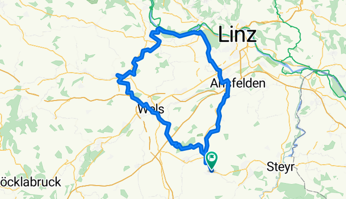
Bad Hall - Wels - Bad Schallerbach - Eferding - Traun - Bad Hall
A cycling route starting in Bad Hall, Upper Austria, Austria.
Overview
About this route
Diese Route beginnt in Bad Hall und führt über Rohr und den Voralpenradweg (R12) nach Wels. Ich verlasse den R12 kurz vor Wels und fahre direkt auf der Bundesstraße nach Wels, um angesichts der Gesamt-KM ein paar KM Umweg einzusparen. Durch die herrliche Altstadt von Wels führt der Panoramaradweg (R19), den man bis Bad Schallerbach folgt, um dann in den Trattnachtalradweg (R17) einzubiegen. In Eferding wechselt man kurzerhand auf den Eferdinger Landlradweg (R18) bis man an die Donau gelangt. Der Donau folgt man bis kurz vor Wilhering um dann, an der Bundesstraße (je nach Tageszeit mehr oder weniger stark befahren) bis Traun zu radeln, wo man noch kurz der Traun entlang in den Kremstalradweg (R10) einmündet um über Rohr nach Bad Hall zurückzukehren!
Die Strecke ist zu Beginn zw. Rohr und Wels hügelig. Ebenfalls muß man zw. Wels und Bad Schallerbach kräftiger in die Pedale treten. Aber danach ist die Route eigentlich durchgehend flach bis leicht ansteigend.
- -:--
- Duration
- 117.5 km
- Distance
- 761 m
- Ascent
- 827 m
- Descent
- ---
- Avg. speed
- 411 m
- Max. altitude
Route quality
Waytypes & surfaces along the route
Waytypes
Quiet road
49.1 km
(42 %)
Road
28.4 km
(24 %)
Surfaces
Paved
63.7 km
(54 %)
Unpaved
5 km
(4 %)
Asphalt
62.4 km
(53 %)
Gravel
3.2 km
(3 %)
Continue with Bikemap
Use, edit, or download this cycling route
You would like to ride Bad Hall - Wels - Bad Schallerbach - Eferding - Traun - Bad Hall or customize it for your own trip? Here is what you can do with this Bikemap route:
Free features
- Save this route as favorite or in collections
- Copy & plan your own version of this route
- Split it into stages to create a multi-day tour
- Sync your route with Garmin or Wahoo
Premium features
Free trial for 3 days, or one-time payment. More about Bikemap Premium.
- Navigate this route on iOS & Android
- Export a GPX / KML file of this route
- Create your custom printout (try it for free)
- Download this route for offline navigation
Discover more Premium features.
Get Bikemap PremiumFrom our community
Other popular routes starting in Bad Hall
 5 Flüsse Runde
- Distance
- 105.6 km
- Ascent
- 432 m
- Descent
- 426 m
- Location
- Bad Hall, Upper Austria, Austria
 Bad Hall - Jageredt - Runde
- Distance
- 36.1 km
- Ascent
- 227 m
- Descent
- 202 m
- Location
- Bad Hall, Upper Austria, Austria
 Bad Hall - Design Center
- Distance
- 37.3 km
- Ascent
- 94 m
- Descent
- 217 m
- Location
- Bad Hall, Upper Austria, Austria
 Hintergebirge Goashansl Runde
- Distance
- 82.9 km
- Ascent
- 1,053 m
- Descent
- 1,051 m
- Location
- Bad Hall, Upper Austria, Austria
 Knackige Fahrt in Bad Hall
- Distance
- 53.8 km
- Ascent
- 943 m
- Descent
- 943 m
- Location
- Bad Hall, Upper Austria, Austria
 2025_04_30_Rohr-Wels-Neuhofen-Rohr
- Distance
- 49.5 km
- Ascent
- 452 m
- Descent
- 455 m
- Location
- Bad Hall, Upper Austria, Austria
 2025_05_21_Rohr-Traunbrücke-Kematen-Rohr
- Distance
- 50.1 km
- Ascent
- 535 m
- Descent
- 533 m
- Location
- Bad Hall, Upper Austria, Austria
 Bad Hall - Enns
- Distance
- 67.5 km
- Ascent
- 632 m
- Descent
- 746 m
- Location
- Bad Hall, Upper Austria, Austria
Open it in the app