

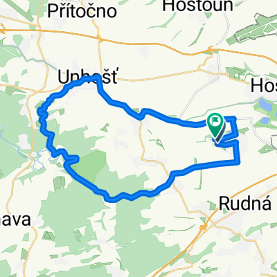
Rudná-Příbram-Mirošov-Hořovice-Rudná
A cycling route starting in Rudná, Central Bohemia, Czechia.
Overview
About this route
The more information you write here, the more useful it will be for other users. * The course of the route. * What is special about this route? * Why recommend this route? * What did you like most here? * etc.
- -:--
- Duration
- 174.2 km
- Distance
- 1,982 m
- Ascent
- 2,074 m
- Descent
- ---
- Avg. speed
- 729 m
- Max. altitude
Route quality
Waytypes & surfaces along the route
Waytypes
Road
54 km
(31 %)
Quiet road
7 km
(4 %)
Surfaces
Paved
64.5 km
(37 %)
Unpaved
3.5 km
(2 %)
Asphalt
64.5 km
(37 %)
Gravel
1.7 km
(1 %)
Continue with Bikemap
Use, edit, or download this cycling route
You would like to ride Rudná-Příbram-Mirošov-Hořovice-Rudná or customize it for your own trip? Here is what you can do with this Bikemap route:
Free features
- Save this route as favorite or in collections
- Copy & plan your own version of this route
- Split it into stages to create a multi-day tour
- Sync your route with Garmin or Wahoo
Premium features
Free trial for 3 days, or one-time payment. More about Bikemap Premium.
- Navigate this route on iOS & Android
- Export a GPX / KML file of this route
- Create your custom printout (try it for free)
- Download this route for offline navigation
Discover more Premium features.
Get Bikemap PremiumFrom our community
Other popular routes starting in Rudná
 Rudá-Křivoklát-Karlštejn-Rudná
- Distance
- 94.3 km
- Ascent
- 1,449 m
- Descent
- 1,462 m
- Location
- Rudná, Central Bohemia, Czechia
 náměstí Junkových do Šolínova
- Distance
- 43.2 km
- Ascent
- 299 m
- Descent
- 491 m
- Location
- Rudná, Central Bohemia, Czechia
 Rudná-Karlík-Kuchař-Rudná
- Distance
- 49.9 km
- Ascent
- 903 m
- Descent
- 903 m
- Location
- Rudná, Central Bohemia, Czechia
 Rudenská
- Distance
- 37.7 km
- Ascent
- 566 m
- Descent
- 565 m
- Location
- Rudná, Central Bohemia, Czechia
 Hlavní do Rozkošného
- Distance
- 38.2 km
- Ascent
- 287 m
- Descent
- 484 m
- Location
- Rudná, Central Bohemia, Czechia
 Rudná-Řevnice-Vlence-Svatý Jan-Loděnice-Rudná
- Distance
- 54 km
- Ascent
- 928 m
- Descent
- 938 m
- Location
- Rudná, Central Bohemia, Czechia
 Vyjizdka kratka
- Distance
- 28 km
- Ascent
- 224 m
- Descent
- 226 m
- Location
- Rudná, Central Bohemia, Czechia
 20180505
- Distance
- 28.8 km
- Ascent
- 254 m
- Descent
- 256 m
- Location
- Rudná, Central Bohemia, Czechia
Open it in the app