

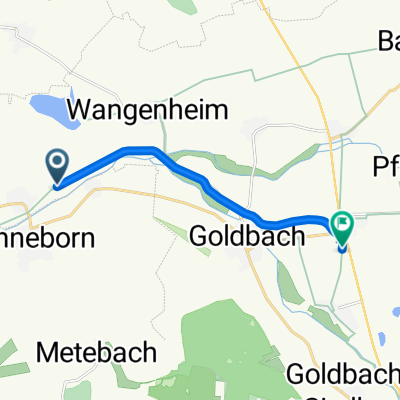
Nessetal-Radweg, Nessetal nach Nessetal
A cycling route starting in Sonneborn, Free State of Thuringia, Germany.
Overview
About this route
- 31 min
- Duration
- 7.8 km
- Distance
- 26 m
- Ascent
- 3 m
- Descent
- 14.9 km/h
- Avg. speed
- 284 m
- Max. altitude
Route quality
Waytypes & surfaces along the route
Waytypes
Cycleway
6.2 km
(80 %)
Access road
0.9 km
(11 %)
Surfaces
Paved
6.8 km
(88 %)
Unpaved
0.5 km
(6 %)
Asphalt
6.8 km
(88 %)
Gravel
0.5 km
(6 %)
Undefined
0.5 km
(6 %)
Continue with Bikemap
Use, edit, or download this cycling route
You would like to ride Nessetal-Radweg, Nessetal nach Nessetal or customize it for your own trip? Here is what you can do with this Bikemap route:
Free features
- Save this route as favorite or in collections
- Copy & plan your own version of this route
- Sync your route with Garmin or Wahoo
Premium features
Free trial for 3 days, or one-time payment. More about Bikemap Premium.
- Navigate this route on iOS & Android
- Export a GPX / KML file of this route
- Create your custom printout (try it for free)
- Download this route for offline navigation
Discover more Premium features.
Get Bikemap PremiumFrom our community
Other popular routes starting in Sonneborn
 Nessetal-Radweg, Nessetal nach Nessetal
- Distance
- 7.8 km
- Ascent
- 26 m
- Descent
- 3 m
- Location
- Sonneborn, Free State of Thuringia, Germany
 Langsame Fahrt in Sonneborn
- Distance
- 20.5 km
- Ascent
- 141 m
- Descent
- 136 m
- Location
- Sonneborn, Free State of Thuringia, Germany
 Sonneborn - Hörselberg
- Distance
- 14.8 km
- Ascent
- 336 m
- Descent
- 126 m
- Location
- Sonneborn, Free State of Thuringia, Germany
 Oberdorf 8, Brüheim nach Haarbergstraße 2, Erfurt
- Distance
- 40.2 km
- Ascent
- 149 m
- Descent
- 164 m
- Location
- Sonneborn, Free State of Thuringia, Germany
 Max-Voß-Straße 40, Sonneborn nach Dieselstraße 10, Großmehring
- Distance
- 338.8 km
- Ascent
- 5,614 m
- Descent
- 5,505 m
- Location
- Sonneborn, Free State of Thuringia, Germany
 Grethengasse 204, Sonneborn nach Hauptstraße 2A, Krauthausen
- Distance
- 41.4 km
- Ascent
- 279 m
- Descent
- 331 m
- Location
- Sonneborn, Free State of Thuringia, Germany
 Rühler Straße 54A, Sonneborn nach Kasseler Straße 3–13, Creuzburg
- Distance
- 31.7 km
- Ascent
- 352 m
- Descent
- 415 m
- Location
- Sonneborn, Free State of Thuringia, Germany
 Oberdorf 4, Brüheim nach Oberdorf 11, Brüheim
- Distance
- 23.6 km
- Ascent
- 259 m
- Descent
- 258 m
- Location
- Sonneborn, Free State of Thuringia, Germany
Open it in the app