
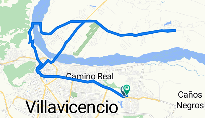
Avenida Francisco José de Caldas, Villavicencio a Villavicencio
A cycling route starting in Villavicencio, Departamento del Meta, Colombia.
Overview
About this route
- 2 h 27 min
- Duration
- 35.3 km
- Distance
- 371 m
- Ascent
- 372 m
- Descent
- 14.4 km/h
- Avg. speed
- 504 m
- Avg. speed

Continue with Bikemap
Use, edit, or download this cycling route
You would like to ride Avenida Francisco José de Caldas, Villavicencio a Villavicencio or customize it for your own trip? Here is what you can do with this Bikemap route:
Free features
- Save this route as favorite or in collections
- Copy & plan your own version of this route
- Sync your route with Garmin or Wahoo
Premium features
Free trial for 3 days, or one-time payment. More about Bikemap Premium.
- Navigate this route on iOS & Android
- Export a GPX / KML file of this route
- Create your custom printout (try it for free)
- Download this route for offline navigation
Discover more Premium features.
Get Bikemap PremiumFrom our community
Other popular routes starting in Villavicencio
 cumbre
- Distance
- 62.6 km
- Ascent
- 971 m
- Descent
- 963 m
- Location
- Villavicencio, Departamento del Meta, Colombia
 De Calle 45 45-1, Villavicencio a Calle 41d 40a236, Villavicencio
- Distance
- 2.9 km
- Ascent
- 28 m
- Descent
- 51 m
- Location
- Villavicencio, Departamento del Meta, Colombia
 4.156, -73.632 a 4.138, -73.648
- Distance
- 25 km
- Ascent
- 467 m
- Descent
- 389 m
- Location
- Villavicencio, Departamento del Meta, Colombia
 Easy ride in Villavicencio
- Distance
- 23.2 km
- Ascent
- 117 m
- Descent
- 104 m
- Location
- Villavicencio, Departamento del Meta, Colombia
 buenavista X3
- Distance
- 48.8 km
- Ascent
- 2,303 m
- Descent
- 1,530 m
- Location
- Villavicencio, Departamento del Meta, Colombia
 Ruta moderada en MTB
- Distance
- 11.1 km
- Ascent
- 115 m
- Descent
- 115 m
- Location
- Villavicencio, Departamento del Meta, Colombia
 Ruta a Vía Vereda el Carmen, Villavicencio
- Distance
- 26.8 km
- Ascent
- 475 m
- Descent
- 189 m
- Location
- Villavicencio, Departamento del Meta, Colombia
 Villavicencio - Pto López
- Distance
- 84.6 km
- Ascent
- 12 m
- Descent
- 315 m
- Location
- Villavicencio, Departamento del Meta, Colombia
Open it in the app